You are here: Home > Network List > TA - USArray Transportable Network (new EarthScope stations) Stations List
> Station R11A Troy Canyon, Currant, NV, USA > Earthquake Result Viewer
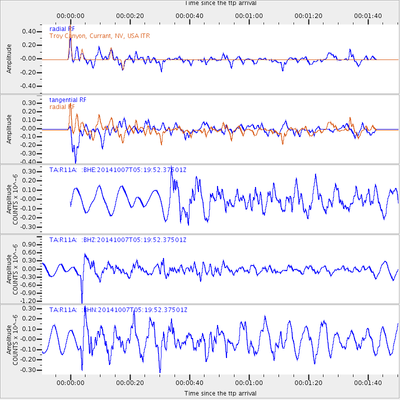
R11A Troy Canyon, Currant, NV, USA - Earthquake Result Viewer
*The percent match for this event was below the threshold and hence no stack was calculated.
| Earthquake location: |
Northern Chile |
| Earthquake latitude/longitude: |
-19.7/-69.7 |
| Earthquake time(UTC): |
2014/10/07 (280) 05:09:10 GMT |
| Earthquake Depth: |
103 km |
| Earthquake Magnitude: |
5.8 MB |
| Earthquake Catalog/Contributor: |
NEIC PDE/NEIC COMCAT |
|
| Network: |
TA USArray Transportable Network (new EarthScope stations) |
| Station: |
R11A Troy Canyon, Currant, NV, USA |
| Lat/Lon: |
38.35 N/115.59 W |
| Elevation: |
1756 m |
|
| Distance: |
72.0 deg |
| Az: |
323.561 deg |
| Baz: |
134.61 deg |
| Ray Param: |
$rayparam |
*The percent match for this event was below the threshold and hence was not used in the summary stack. |
|
| Radial Match: |
65.73924 % |
| Radial Bump: |
400 |
| Transverse Match: |
74.16151 % |
| Transverse Bump: |
400 |
| SOD ConfigId: |
796777 |
| Insert Time: |
2014-10-21 05:45:21.587 +0000 |
| GWidth: |
2.5 |
| Max Bumps: |
400 |
| Tol: |
0.001 |
|
Signal To Noise
| Channel | StoN | STA | LTA |
| TA:R11A: :BHZ:20141007T05:19:52.37501Z | 2.3201451 | 3.4166385E-7 | 1.4725968E-7 |
| TA:R11A: :BHN:20141007T05:19:52.37501Z | 1.273295 | 1.1826526E-7 | 9.288127E-8 |
| TA:R11A: :BHE:20141007T05:19:52.37501Z | 1.8075898 | 1.622294E-7 | 8.974902E-8 |
| Arrivals |
| Ps | |
| PpPs | |
| PsPs/PpSs | |


