You are here: Home > Network List > IU - Global Seismograph Network (GSN - IRIS/USGS) Stations List
> Station WVT Waverly, Tennessee, USA > Earthquake Result Viewer
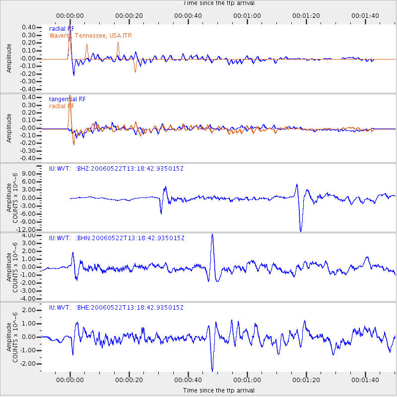
WVT Waverly, Tennessee, USA - Earthquake Result Viewer

| Earthquake location: |
Kamchatka Peninsula, Russia |
| Earthquake latitude/longitude: |
54.3/158.4 |
| Earthquake time(UTC): |
2006/05/22 (142) 13:08:01 GMT |
| Earthquake Depth: |
185 km |
| Earthquake Magnitude: |
6.2 MB, 6.2 MW, 6.2 MW |
| Earthquake Catalog/Contributor: |
WHDF/NEIC |
|
| Network: |
IU Global Seismograph Network (GSN - IRIS/USGS) |
| Station: |
WVT Waverly, Tennessee, USA |
| Lat/Lon: |
36.13 N/87.83 W |
| Elevation: |
157 m |
|
| Distance: |
73.5 deg |
| Az: |
50.621 deg |
| Baz: |
325.949 deg |
| Ray Param: |
0.052484095 |
| Estimated Moho Depth: |
42.25 km |
| Estimated Crust Vp/Vs: |
1.86 |
| Assumed Crust Vp: |
6.444 km/s |
| Estimated Crust Vs: |
3.474 km/s |
| Estimated Crust Poisson's Ratio: |
0.30 |
|
| Radial Match: |
89.96912 % |
| Radial Bump: |
337 |
| Transverse Match: |
82.06219 % |
| Transverse Bump: |
400 |
| SOD ConfigId: |
2669 |
| Insert Time: |
2010-03-02 02:03:37.808 +0000 |
| GWidth: |
2.5 |
| Max Bumps: |
400 |
| Tol: |
0.001 |
|
Signal To Noise
| Channel | StoN | STA | LTA |
| IU:WVT: :BHN:20060522T13:18:42.935015Z | 6.27706 | 8.666866E-7 | 1.3807205E-7 |
| IU:WVT: :BHE:20060522T13:18:42.935015Z | 3.7397585 | 6.178257E-7 | 1.6520472E-7 |
| IU:WVT: :BHZ:20060522T13:18:42.935015Z | 6.2989173 | 2.3188645E-6 | 3.68137E-7 |
| Arrivals |
| Ps | 5.8 SECOND |
| PpPs | 18 SECOND |
| PsPs/PpSs | 24 SECOND |


