You are here: Home > Network List > IU - Global Seismograph Network (GSN - IRIS/USGS) Stations List
> Station WVT Waverly, Tennessee, USA > Earthquake Result Viewer
WVT Waverly, Tennessee, USA - Earthquake Result Viewer
| Earthquake location: |
Panama-Colombia Border Region |
| Earthquake latitude/longitude: |
7.0/-77.8 |
| Earthquake time(UTC): |
2000/11/08 (313) 06:59:58 GMT |
| Earthquake Depth: |
17 km |
| Earthquake Magnitude: |
6.0 MB, 6.4 MS, 6.5 MW, 6.2 ML |
| Earthquake Catalog/Contributor: |
WHDF/NEIC |
|
| Network: |
IU Global Seismograph Network (GSN - IRIS/USGS) |
| Station: |
WVT Waverly, Tennessee, USA |
| Lat/Lon: |
36.13 N/87.83 W |
| Elevation: |
157 m |
|
| Distance: |
30.4 deg |
| Az: |
343.852 deg |
| Baz: |
160.063 deg |
| Ray Param: |
0.07934253 |
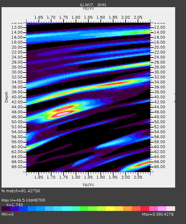
| Estimated Moho Depth: |
46.5 km |
| Estimated Crust Vp/Vs: |
1.75 |
| Assumed Crust Vp: |
6.444 km/s |
| Estimated Crust Vs: |
3.693 km/s |
| Estimated Crust Poisson's Ratio: |
0.26 |
|
| Radial Match: |
91.42758 % |
| Radial Bump: |
333 |
| Transverse Match: |
62.624413 % |
| Transverse Bump: |
400 |
| SOD ConfigId: |
3744 |
| Insert Time: |
2010-03-02 02:03:46.241 +0000 |
| GWidth: |
2.5 |
| Max Bumps: |
400 |
| Tol: |
0.001 |
|
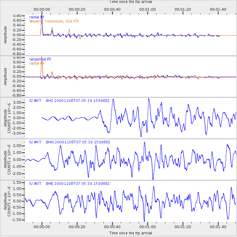
Signal To Noise
| Channel | StoN | STA | LTA |
| IU:WVT: :BHN:20001108T07:05:39.159988Z | 2.416905 | 4.7265985E-7 | 1.9556411E-7 |
| IU:WVT: :BHE:20001108T07:05:39.159988Z | 1.47086 | 2.549924E-7 | 1.7336278E-7 |
| IU:WVT: :BHZ:20001108T07:05:39.159988Z | 2.9768574 | 6.614932E-7 | 2.2221191E-7 |
| Arrivals |
| Ps | 5.8 SECOND |
| PpPs | 18 SECOND |
| PsPs/PpSs | 24 SECOND |


