You are here: Home > Network List > CI - Caltech Regional Seismic Network Stations List
> Station CWC Cottonwood Creek, California, USA > Earthquake Result Viewer
CWC Cottonwood Creek, California, USA - Earthquake Result Viewer
| Earthquake location: |
Caribbean Sea |
| Earthquake latitude/longitude: |
19.0/-81.4 |
| Earthquake time(UTC): |
2004/12/14 (349) 23:20:13 GMT |
| Earthquake Depth: |
10 km |
| Earthquake Magnitude: |
6.2 MB, 6.7 MS, 6.8 MW, 6.8 MW |
| Earthquake Catalog/Contributor: |
WHDF/NEIC |
|
| Network: |
CI Caltech Regional Seismic Network |
| Station: |
CWC Cottonwood Creek, California, USA |
| Lat/Lon: |
36.44 N/118.08 W |
| Elevation: |
1553 m |
|
| Distance: |
36.6 deg |
| Az: |
306.074 deg |
| Baz: |
108.446 deg |
| Ray Param: |
0.076607436 |
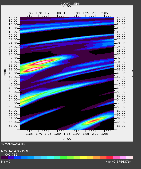
| Estimated Moho Depth: |
34.0 km |
| Estimated Crust Vp/Vs: |
1.72 |
| Assumed Crust Vp: |
6.291 km/s |
| Estimated Crust Vs: |
3.668 km/s |
| Estimated Crust Poisson's Ratio: |
0.24 |
|
| Radial Match: |
94.0689 % |
| Radial Bump: |
400 |
| Transverse Match: |
86.16119 % |
| Transverse Bump: |
400 |
| SOD ConfigId: |
2459 |
| Insert Time: |
2010-02-25 21:17:59.804 +0000 |
| GWidth: |
2.5 |
| Max Bumps: |
400 |
| Tol: |
0.001 |
|
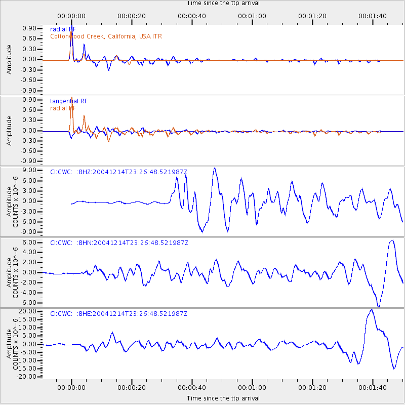
Signal To Noise
| Channel | StoN | STA | LTA |
| CI:CWC: :BHN:20041214T23:26:48.521987Z | 0.41248643 | 1.1197601E-7 | 2.7146592E-7 |
| CI:CWC: :BHE:20041214T23:26:48.521987Z | 4.2390523 | 8.9268747E-7 | 2.1058658E-7 |
| CI:CWC: :BHZ:20041214T23:26:48.521987Z | 10.454531 | 2.0983848E-6 | 2.0071536E-7 |
| Arrivals |
| Ps | 4.2 SECOND |
| PpPs | 14 SECOND |
| PsPs/PpSs | 18 SECOND |


