You are here: Home > Network List > XD14 - Illuminating the architecture of the greater Mount St. Helens magmatic systems f Stations List
> Station MO06 "Mount St Helens, WA" > Earthquake Result Viewer
MO06 "Mount St Helens, WA" - Earthquake Result Viewer
| Earthquake location: |
New Britain Region, P.N.G. |
| Earthquake latitude/longitude: |
-5.2/151.8 |
| Earthquake time(UTC): |
2015/05/01 (121) 08:06:05 GMT |
| Earthquake Depth: |
54 km |
| Earthquake Magnitude: |
7.1 MO |
| Earthquake Catalog/Contributor: |
NEIC PDE/NEIC ALERT |
|
| Network: |
XD Illuminating the architecture of the greater Mount St. Helens magmatic systems f |
| Station: |
MO06 "Mount St Helens, WA" |
| Lat/Lon: |
45.93 N/122.21 W |
| Elevation: |
784 m |
|
| Distance: |
90.9 deg |
| Az: |
44.133 deg |
| Baz: |
263.537 deg |
| Ray Param: |
0.04162868 |
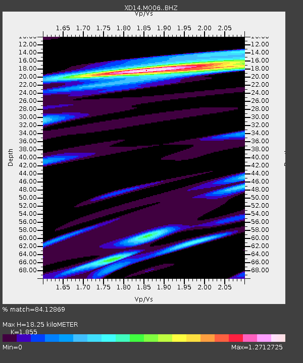
| Estimated Moho Depth: |
18.25 km |
| Estimated Crust Vp/Vs: |
1.86 |
| Assumed Crust Vp: |
6.566 km/s |
| Estimated Crust Vs: |
3.54 km/s |
| Estimated Crust Poisson's Ratio: |
0.30 |
|
| Radial Match: |
84.12869 % |
| Radial Bump: |
400 |
| Transverse Match: |
59.812054 % |
| Transverse Bump: |
400 |
| SOD ConfigId: |
7422571 |
| Insert Time: |
2019-04-18 15:03:46.297 +0000 |
| GWidth: |
2.5 |
| Max Bumps: |
400 |
| Tol: |
0.001 |
|

Signal To Noise
| Channel | StoN | STA | LTA |
| XD:MO06: :BHZ:20150501T08:18:31.279993Z | 9.247272 | 1.8736781E-6 | 2.0261956E-7 |
| XD:MO06: :BHN:20150501T08:18:31.279993Z | 2.092658 | 3.0274174E-7 | 1.4466852E-7 |
| XD:MO06: :BHE:20150501T08:18:31.279993Z | 2.199145 | 5.465337E-7 | 2.48521E-7 |
| Arrivals |
| Ps | 2.4 SECOND |
| PpPs | 7.8 SECOND |
| PsPs/PpSs | 10 SECOND |


