You are here: Home > Network List > YT07 - POLENET Stations List
> Station ALYS ALYS > Earthquake Result Viewer
ALYS ALYS - Earthquake Result Viewer
| Earthquake location: |
New Britain Region, P.N.G. |
| Earthquake latitude/longitude: |
-5.2/151.8 |
| Earthquake time(UTC): |
2015/05/01 (121) 08:06:05 GMT |
| Earthquake Depth: |
54 km |
| Earthquake Magnitude: |
7.1 MO |
| Earthquake Catalog/Contributor: |
NEIC PDE/NEIC ALERT |
|
| Network: |
YT POLENET |
| Station: |
ALYS ALYS |
| Lat/Lon: |
84.35 S/23.73 W |
| Elevation: |
2084 m |
|
| Distance: |
90.5 deg |
| Az: |
180.444 deg |
| Baz: |
175.527 deg |
| Ray Param: |
0.04166145 |
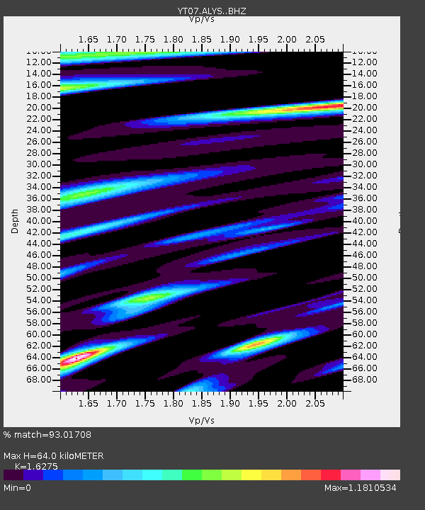
| Estimated Moho Depth: |
64.0 km |
| Estimated Crust Vp/Vs: |
1.63 |
| Assumed Crust Vp: |
6.356 km/s |
| Estimated Crust Vs: |
3.906 km/s |
| Estimated Crust Poisson's Ratio: |
0.20 |
|
| Radial Match: |
93.01708 % |
| Radial Bump: |
362 |
| Transverse Match: |
85.96563 % |
| Transverse Bump: |
353 |
| SOD ConfigId: |
7422571 |
| Insert Time: |
2019-04-18 15:04:35.892 +0000 |
| GWidth: |
2.5 |
| Max Bumps: |
400 |
| Tol: |
0.001 |
|

Signal To Noise
| Channel | StoN | STA | LTA |
| YT:ALYS: :BHZ:20150501T08:18:29.224023Z | 11.312558 | 2.8144234E-6 | 2.4878753E-7 |
| YT:ALYS: :BHN:20150501T08:18:29.224023Z | 4.5511093 | 9.0775075E-7 | 1.9945702E-7 |
| YT:ALYS: :BHE:20150501T08:18:29.224023Z | 1.0037421 | 2.8449006E-7 | 2.8342942E-7 |
| Arrivals |
| Ps | 6.5 SECOND |
| PpPs | 26 SECOND |
| PsPs/PpSs | 32 SECOND |


