You are here: Home > Network List > AK - Alaska Regional Network Stations List
> Station CUT Chulitna, AK, USA > Earthquake Result Viewer
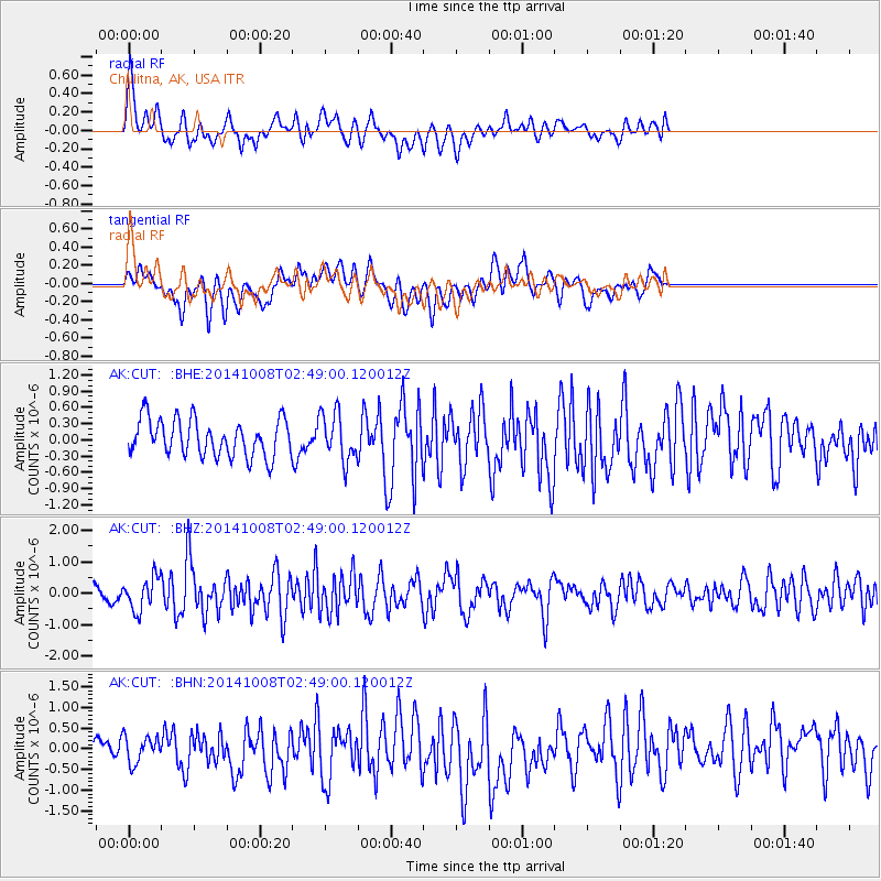
CUT Chulitna, AK, USA - Earthquake Result Viewer
*The percent match for this event was below the threshold and hence no stack was calculated.
| Earthquake location: |
Gulf Of California |
| Earthquake latitude/longitude: |
23.8/-108.4 |
| Earthquake time(UTC): |
2014/10/08 (281) 02:40:54 GMT |
| Earthquake Depth: |
10 km |
| Earthquake Magnitude: |
6.2 MWP |
| Earthquake Catalog/Contributor: |
NEIC PDE/NEIC COMCAT |
|
| Network: |
AK Alaska Regional Network |
| Station: |
CUT Chulitna, AK, USA |
| Lat/Lon: |
62.41 N/150.26 W |
| Elevation: |
574 m |
|
| Distance: |
47.7 deg |
| Az: |
335.166 deg |
| Baz: |
124.308 deg |
| Ray Param: |
$rayparam |
*The percent match for this event was below the threshold and hence was not used in the summary stack. |
|
| Radial Match: |
59.184345 % |
| Radial Bump: |
400 |
| Transverse Match: |
61.87894 % |
| Transverse Bump: |
400 |
| SOD ConfigId: |
803114 |
| Insert Time: |
2014-10-22 02:58:44.825 +0000 |
| GWidth: |
2.5 |
| Max Bumps: |
400 |
| Tol: |
0.001 |
|
Signal To Noise
| Channel | StoN | STA | LTA |
| AK:CUT: :BHZ:20141008T02:49:00.120012Z | 2.4624069 | 5.140494E-7 | 2.0875893E-7 |
| AK:CUT: :BHN:20141008T02:49:00.120012Z | 1.6620334 | 3.391227E-7 | 2.0404084E-7 |
| AK:CUT: :BHE:20141008T02:49:00.120012Z | 1.2951037 | 4.4192737E-7 | 3.4122934E-7 |
| Arrivals |
| Ps | |
| PpPs | |
| PsPs/PpSs | |


