You are here: Home > Network List > CN - Canadian National Seismograph Network Stations List
> Station YKAW1 Yellowknife White 1, NT > Earthquake Result Viewer
YKAW1 Yellowknife White 1, NT - Earthquake Result Viewer
| Earthquake location: |
Gulf Of California |
| Earthquake latitude/longitude: |
23.8/-108.4 |
| Earthquake time(UTC): |
2014/10/08 (281) 02:40:54 GMT |
| Earthquake Depth: |
10 km |
| Earthquake Magnitude: |
6.2 MWP |
| Earthquake Catalog/Contributor: |
NEIC PDE/NEIC COMCAT |
|
| Network: |
CN Canadian National Seismograph Network |
| Station: |
YKAW1 Yellowknife White 1, NT |
| Lat/Lon: |
62.13 N/114.15 W |
| Elevation: |
198 m |
|
| Distance: |
38.5 deg |
| Az: |
355.68 deg |
| Baz: |
171.557 deg |
| Ray Param: |
0.0755267 |
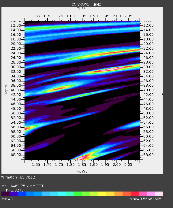
| Estimated Moho Depth: |
69.75 km |
| Estimated Crust Vp/Vs: |
1.83 |
| Assumed Crust Vp: |
6.459 km/s |
| Estimated Crust Vs: |
3.535 km/s |
| Estimated Crust Poisson's Ratio: |
0.29 |
|
| Radial Match: |
83.7012 % |
| Radial Bump: |
359 |
| Transverse Match: |
61.273506 % |
| Transverse Bump: |
400 |
| SOD ConfigId: |
803114 |
| Insert Time: |
2014-10-22 03:01:53.047 +0000 |
| GWidth: |
2.5 |
| Max Bumps: |
400 |
| Tol: |
0.001 |
|

Signal To Noise
| Channel | StoN | STA | LTA |
| CN:YKAW1: :BHZ:20141008T02:47:45.874987Z | 4.1953874 | 5.541945E-7 | 1.3209613E-7 |
| CN:YKAW1: :BHN:20141008T02:47:45.874987Z | 1.9271455 | 2.4356154E-7 | 1.2638462E-7 |
| CN:YKAW1: :BHE:20141008T02:47:45.874987Z | 0.3038909 | 4.0056502E-8 | 1.3181212E-7 |
| Arrivals |
| Ps | 9.6 SECOND |
| PpPs | 28 SECOND |
| PsPs/PpSs | 38 SECOND |


