You are here: Home > Network List > IU - Global Seismograph Network (GSN - IRIS/USGS) Stations List
> Station WVT Waverly, Tennessee, USA > Earthquake Result Viewer
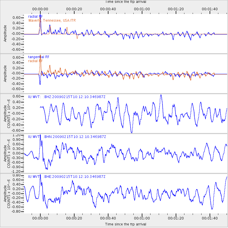
WVT Waverly, Tennessee, USA - Earthquake Result Viewer
*The percent match for this event was below the threshold and hence no stack was calculated.
| Earthquake location: |
Near Coast Of Northern Peru |
| Earthquake latitude/longitude: |
-5.9/-80.9 |
| Earthquake time(UTC): |
2009/02/15 (046) 10:04:49 GMT |
| Earthquake Depth: |
21 km |
| Earthquake Magnitude: |
5.8 MB, 5.7 MS, 6.1 MW, 6.1 MW |
| Earthquake Catalog/Contributor: |
WHDF/NEIC |
|
| Network: |
IU Global Seismograph Network (GSN - IRIS/USGS) |
| Station: |
WVT Waverly, Tennessee, USA |
| Lat/Lon: |
36.13 N/87.83 W |
| Elevation: |
157 m |
|
| Distance: |
42.3 deg |
| Az: |
351.639 deg |
| Baz: |
169.706 deg |
| Ray Param: |
$rayparam |
*The percent match for this event was below the threshold and hence was not used in the summary stack. |
|
| Radial Match: |
67.28679 % |
| Radial Bump: |
400 |
| Transverse Match: |
48.072212 % |
| Transverse Bump: |
400 |
| SOD ConfigId: |
2658 |
| Insert Time: |
2010-03-02 02:04:41.164 +0000 |
| GWidth: |
2.5 |
| Max Bumps: |
400 |
| Tol: |
0.001 |
|
Signal To Noise
| Channel | StoN | STA | LTA |
| IU:WVT: :BHN:20090215T10:12:10.346987Z | 3.4330559 | 7.1846773E-7 | 2.0927935E-7 |
| IU:WVT: :BHE:20090215T10:12:10.346987Z | 2.0183816 | 4.2872972E-7 | 2.124126E-7 |
| IU:WVT: :BHZ:20090215T10:12:10.346987Z | 1.3057172 | 2.8074496E-7 | 2.1501205E-7 |
| Arrivals |
| Ps | |
| PpPs | |
| PsPs/PpSs | |


