You are here: Home > Network List > TA - USArray Transportable Network (new EarthScope stations) Stations List
> Station A21K Barrow, AK, USA > Earthquake Result Viewer
A21K Barrow, AK, USA - Earthquake Result Viewer

| Earthquake location: |
New Britain Region, P.N.G. |
| Earthquake latitude/longitude: |
-5.4/151.8 |
| Earthquake time(UTC): |
2015/05/01 (121) 08:06:53 GMT |
| Earthquake Depth: |
45 km |
| Earthquake Magnitude: |
6.0 mb |
| Earthquake Catalog/Contributor: |
ISC/ISC |
|
| Network: |
TA USArray Transportable Network (new EarthScope stations) |
| Station: |
A21K Barrow, AK, USA |
| Lat/Lon: |
71.32 N/156.62 W |
| Elevation: |
577 m |
|
| Distance: |
83.6 deg |
| Az: |
14.718 deg |
| Baz: |
231.729 deg |
| Ray Param: |
0.04597211 |
| Estimated Moho Depth: |
32.0 km |
| Estimated Crust Vp/Vs: |
1.72 |
| Assumed Crust Vp: |
6.048 km/s |
| Estimated Crust Vs: |
3.516 km/s |
| Estimated Crust Poisson's Ratio: |
0.24 |
|
| Radial Match: |
84.24841 % |
| Radial Bump: |
400 |
| Transverse Match: |
71.67674 % |
| Transverse Bump: |
400 |
| SOD ConfigId: |
7422571 |
| Insert Time: |
2019-04-18 15:08:11.691 +0000 |
| GWidth: |
2.5 |
| Max Bumps: |
400 |
| Tol: |
0.001 |
|
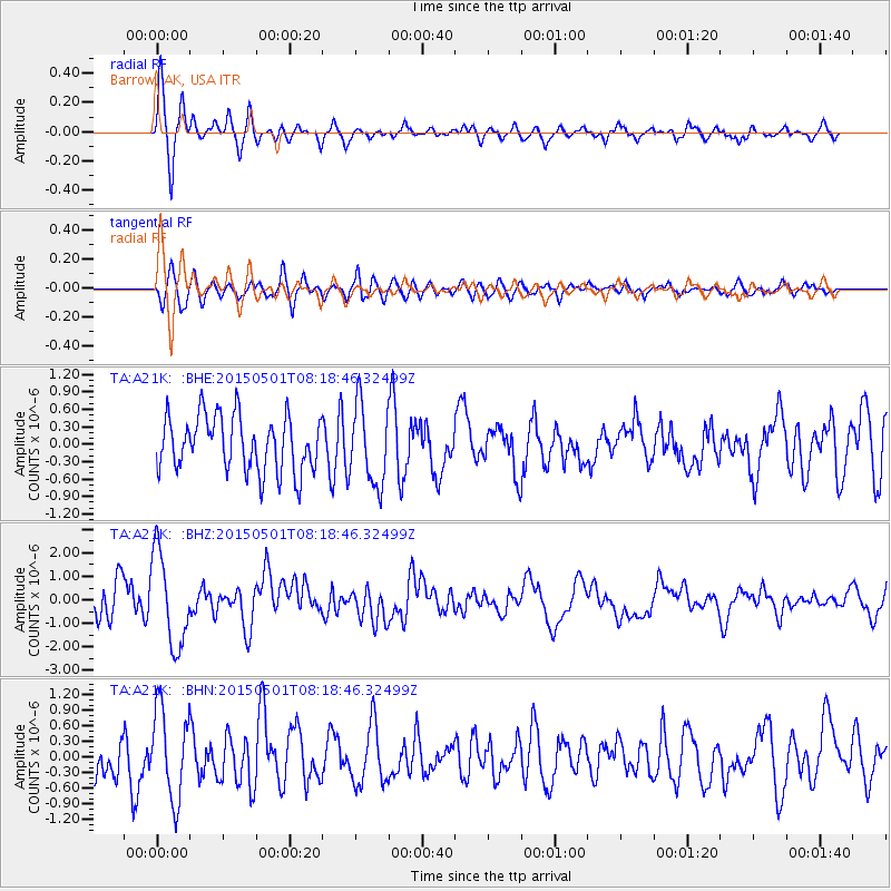
Signal To Noise
| Channel | StoN | STA | LTA |
| TA:A21K: :BHZ:20150501T08:18:46.32499Z | 2.1309776 | 1.9796898E-6 | 9.2900547E-7 |
| TA:A21K: :BHN:20150501T08:18:46.32499Z | 1.6779293 | 8.6334194E-7 | 5.145282E-7 |
| TA:A21K: :BHE:20150501T08:18:46.32499Z | 1.4527141 | 6.9122825E-7 | 4.758185E-7 |
| Arrivals |
| Ps | 3.9 SECOND |
| PpPs | 14 SECOND |
| PsPs/PpSs | 18 SECOND |


