You are here: Home > Network List > NE - New England Seismic Network Stations List
> Station QUA2 Belchertown, MA, USA > Earthquake Result Viewer
QUA2 Belchertown, MA, USA - Earthquake Result Viewer
| Earthquake location: |
Gulf Of California |
| Earthquake latitude/longitude: |
23.8/-108.4 |
| Earthquake time(UTC): |
2014/10/08 (281) 02:40:54 GMT |
| Earthquake Depth: |
10 km |
| Earthquake Magnitude: |
6.2 MWP |
| Earthquake Catalog/Contributor: |
NEIC PDE/NEIC COMCAT |
|
| Network: |
NE New England Seismic Network |
| Station: |
QUA2 Belchertown, MA, USA |
| Lat/Lon: |
42.28 N/72.35 W |
| Elevation: |
168 m |
|
| Distance: |
35.1 deg |
| Az: |
49.516 deg |
| Baz: |
249.821 deg |
| Ray Param: |
0.07741772 |
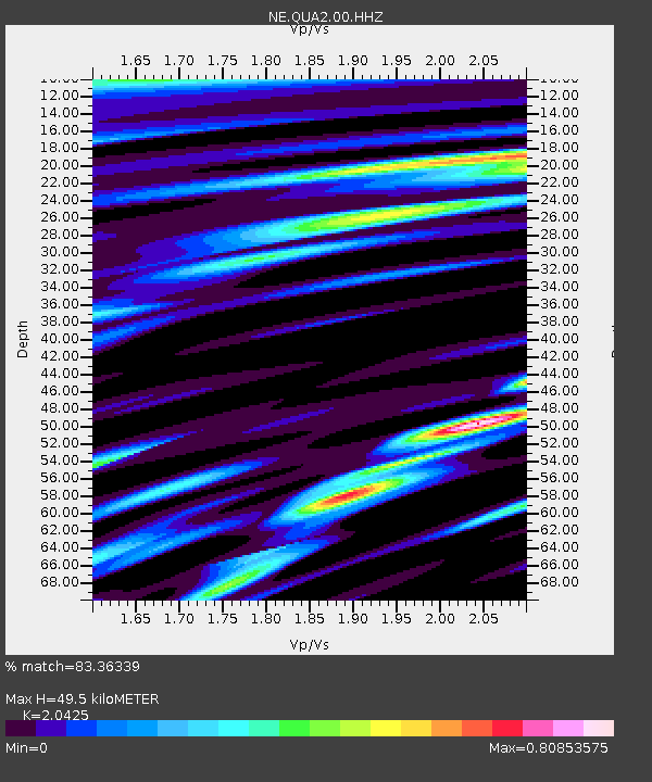
| Estimated Moho Depth: |
49.5 km |
| Estimated Crust Vp/Vs: |
2.04 |
| Assumed Crust Vp: |
6.419 km/s |
| Estimated Crust Vs: |
3.143 km/s |
| Estimated Crust Poisson's Ratio: |
0.34 |
|
| Radial Match: |
83.36339 % |
| Radial Bump: |
400 |
| Transverse Match: |
68.342636 % |
| Transverse Bump: |
400 |
| SOD ConfigId: |
803114 |
| Insert Time: |
2014-10-22 03:07:21.695 +0000 |
| GWidth: |
2.5 |
| Max Bumps: |
400 |
| Tol: |
0.001 |
|

Signal To Noise
| Channel | StoN | STA | LTA |
| NE:QUA2:00:HHZ:20141008T02:47:16.668993Z | 4.022645 | 7.900261E-7 | 1.963947E-7 |
| NE:QUA2:00:HH1:20141008T02:47:16.668993Z | 1.5700561 | 2.4880865E-7 | 1.5847118E-7 |
| NE:QUA2:00:HH2:20141008T02:47:16.668993Z | 2.7629027 | 4.0332836E-7 | 1.4597993E-7 |
| Arrivals |
| Ps | 8.6 SECOND |
| PpPs | 22 SECOND |
| PsPs/PpSs | 31 SECOND |


