You are here: Home > Network List > PE - Penn State Network Stations List
> Station WRPS We R Penn State > Earthquake Result Viewer
WRPS We R Penn State - Earthquake Result Viewer
| Earthquake location: |
Gulf Of California |
| Earthquake latitude/longitude: |
23.8/-108.4 |
| Earthquake time(UTC): |
2014/10/08 (281) 02:40:54 GMT |
| Earthquake Depth: |
10 km |
| Earthquake Magnitude: |
6.2 MWP |
| Earthquake Catalog/Contributor: |
NEIC PDE/NEIC COMCAT |
|
| Network: |
PE Penn State Network |
| Station: |
WRPS We R Penn State |
| Lat/Lon: |
40.79 N/77.87 W |
| Elevation: |
320 m |
|
| Distance: |
30.7 deg |
| Az: |
49.171 deg |
| Baz: |
245.888 deg |
| Ray Param: |
0.07927042 |
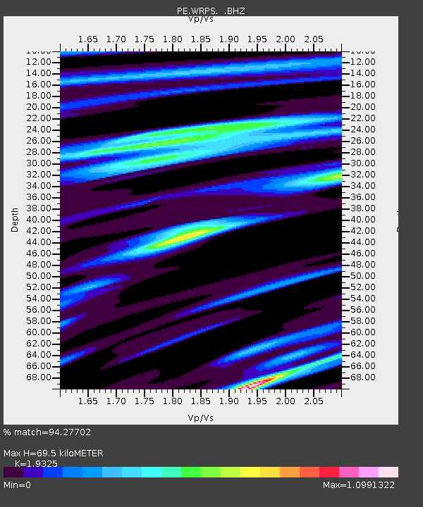
| Estimated Moho Depth: |
69.5 km |
| Estimated Crust Vp/Vs: |
1.93 |
| Assumed Crust Vp: |
6.121 km/s |
| Estimated Crust Vs: |
3.167 km/s |
| Estimated Crust Poisson's Ratio: |
0.32 |
|
| Radial Match: |
94.27702 % |
| Radial Bump: |
309 |
| Transverse Match: |
72.300735 % |
| Transverse Bump: |
400 |
| SOD ConfigId: |
803114 |
| Insert Time: |
2014-10-22 03:07:58.836 +0000 |
| GWidth: |
2.5 |
| Max Bumps: |
400 |
| Tol: |
0.001 |
|
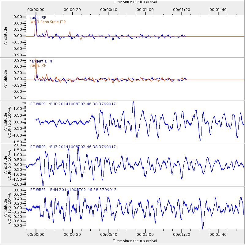
Signal To Noise
| Channel | StoN | STA | LTA |
| PE:WRPS: :BHZ:20141008T02:46:38.379991Z | 5.6436796 | 9.253419E-7 | 1.6396075E-7 |
| PE:WRPS: :BHN:20141008T02:46:38.379991Z | 1.482711 | 1.9803188E-7 | 1.3356068E-7 |
| PE:WRPS: :BHE:20141008T02:46:38.379991Z | 5.16867 | 5.84398E-7 | 1.13065454E-7 |
| Arrivals |
| Ps | 11 SECOND |
| PpPs | 31 SECOND |
| PsPs/PpSs | 42 SECOND |


