You are here: Home > Network List > PR - Puerto Rico Seismic Network (PRSN) & Puerto Rico Strong Motion Program (PRSMP) Stations List
> Station AGPR Aguadilla > Earthquake Result Viewer
AGPR Aguadilla - Earthquake Result Viewer
| Earthquake location: |
Gulf Of California |
| Earthquake latitude/longitude: |
23.8/-108.4 |
| Earthquake time(UTC): |
2014/10/08 (281) 02:40:54 GMT |
| Earthquake Depth: |
10 km |
| Earthquake Magnitude: |
6.2 MWP |
| Earthquake Catalog/Contributor: |
NEIC PDE/NEIC COMCAT |
|
| Network: |
PR Puerto Rico Seismic Network (PRSN) & Puerto Rico Strong Motion Program (PRSMP) |
| Station: |
AGPR Aguadilla |
| Lat/Lon: |
18.47 N/67.11 W |
| Elevation: |
120 m |
|
| Distance: |
38.8 deg |
| Az: |
89.809 deg |
| Baz: |
285.223 deg |
| Ray Param: |
0.07535346 |
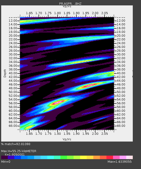
| Estimated Moho Depth: |
55.25 km |
| Estimated Crust Vp/Vs: |
1.81 |
| Assumed Crust Vp: |
5.14 km/s |
| Estimated Crust Vs: |
2.848 km/s |
| Estimated Crust Poisson's Ratio: |
0.28 |
|
| Radial Match: |
92.81098 % |
| Radial Bump: |
366 |
| Transverse Match: |
72.93777 % |
| Transverse Bump: |
400 |
| SOD ConfigId: |
803114 |
| Insert Time: |
2014-10-22 03:08:53.785 +0000 |
| GWidth: |
2.5 |
| Max Bumps: |
400 |
| Tol: |
0.001 |
|

Signal To Noise
| Channel | StoN | STA | LTA |
| PR:AGPR: :BHZ:20141008T02:47:48.374987Z | 6.302283 | 2.3897933E-6 | 3.7919486E-7 |
| PR:AGPR: :BHN:20141008T02:47:48.374987Z | 1.3802454 | 7.288582E-7 | 5.2806416E-7 |
| PR:AGPR: :BHE:20141008T02:47:48.374987Z | 2.2263129 | 9.703169E-7 | 4.3584035E-7 |
| Arrivals |
| Ps | 9.0 SECOND |
| PpPs | 29 SECOND |
| PsPs/PpSs | 38 SECOND |


