You are here: Home > Network List > PR - Puerto Rico Seismic Network (PRSN) & Puerto Rico Strong Motion Program (PRSMP) Stations List
> Station MPR RUM > Earthquake Result Viewer
MPR RUM - Earthquake Result Viewer
| Earthquake location: |
Gulf Of California |
| Earthquake latitude/longitude: |
23.8/-108.4 |
| Earthquake time(UTC): |
2014/10/08 (281) 02:40:54 GMT |
| Earthquake Depth: |
10 km |
| Earthquake Magnitude: |
6.2 MWP |
| Earthquake Catalog/Contributor: |
NEIC PDE/NEIC COMCAT |
|
| Network: |
PR Puerto Rico Seismic Network (PRSN) & Puerto Rico Strong Motion Program (PRSMP) |
| Station: |
MPR RUM |
| Lat/Lon: |
18.21 N/67.14 W |
| Elevation: |
22 m |
|
| Distance: |
38.8 deg |
| Az: |
90.212 deg |
| Baz: |
285.528 deg |
| Ray Param: |
0.07532962 |
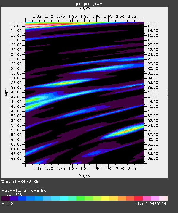
| Estimated Moho Depth: |
11.75 km |
| Estimated Crust Vp/Vs: |
1.62 |
| Assumed Crust Vp: |
5.14 km/s |
| Estimated Crust Vs: |
3.163 km/s |
| Estimated Crust Poisson's Ratio: |
0.20 |
|
| Radial Match: |
84.321365 % |
| Radial Bump: |
400 |
| Transverse Match: |
79.32301 % |
| Transverse Bump: |
400 |
| SOD ConfigId: |
803114 |
| Insert Time: |
2014-10-22 03:09:16.629 +0000 |
| GWidth: |
2.5 |
| Max Bumps: |
400 |
| Tol: |
0.001 |
|

Signal To Noise
| Channel | StoN | STA | LTA |
| PR:MPR: :BHZ:20141008T02:47:48.719988Z | 7.4230266 | 1.982794E-6 | 2.6711393E-7 |
| PR:MPR: :BHN:20141008T02:47:48.719988Z | 1.7136934 | 3.9787525E-7 | 2.3217413E-7 |
| PR:MPR: :BHE:20141008T02:47:48.719988Z | 3.497574 | 9.5028844E-7 | 2.716993E-7 |
| Arrivals |
| Ps | 1.5 SECOND |
| PpPs | 5.7 SECOND |
| PsPs/PpSs | 7.2 SECOND |


