You are here: Home > Network List > TA - USArray Transportable Network (new EarthScope stations) Stations List
> Station D62A Allapoint, Allagash, ME, USA > Earthquake Result Viewer
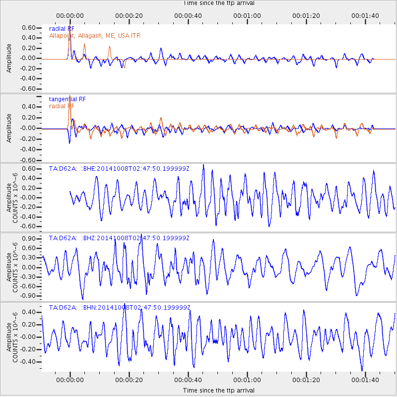
D62A Allapoint, Allagash, ME, USA - Earthquake Result Viewer
*The percent match for this event was below the threshold and hence no stack was calculated.
| Earthquake location: |
Gulf Of California |
| Earthquake latitude/longitude: |
23.8/-108.4 |
| Earthquake time(UTC): |
2014/10/08 (281) 02:40:54 GMT |
| Earthquake Depth: |
10 km |
| Earthquake Magnitude: |
6.2 MWP |
| Earthquake Catalog/Contributor: |
NEIC PDE/NEIC COMCAT |
|
| Network: |
TA USArray Transportable Network (new EarthScope stations) |
| Station: |
D62A Allapoint, Allagash, ME, USA |
| Lat/Lon: |
47.08 N/69.05 W |
| Elevation: |
189 m |
|
| Distance: |
39.0 deg |
| Az: |
43.524 deg |
| Baz: |
247.35 deg |
| Ray Param: |
$rayparam |
*The percent match for this event was below the threshold and hence was not used in the summary stack. |
|
| Radial Match: |
70.38845 % |
| Radial Bump: |
332 |
| Transverse Match: |
57.954178 % |
| Transverse Bump: |
400 |
| SOD ConfigId: |
803114 |
| Insert Time: |
2014-10-22 03:10:07.770 +0000 |
| GWidth: |
2.5 |
| Max Bumps: |
400 |
| Tol: |
0.001 |
|
Signal To Noise
| Channel | StoN | STA | LTA |
| TA:D62A: :BHZ:20141008T02:47:50.199999Z | 2.5126822 | 4.686888E-7 | 1.8652928E-7 |
| TA:D62A: :BHN:20141008T02:47:50.199999Z | 0.58572817 | 1.1956362E-7 | 2.0412818E-7 |
| TA:D62A: :BHE:20141008T02:47:50.199999Z | 0.8881072 | 1.7183312E-7 | 1.934824E-7 |
| Arrivals |
| Ps | |
| PpPs | |
| PsPs/PpSs | |


