You are here: Home > Network List > TA - USArray Transportable Network (new EarthScope stations) Stations List
> Station J55A Hilton, NY, USA > Earthquake Result Viewer
J55A Hilton, NY, USA - Earthquake Result Viewer

| Earthquake location: |
Gulf Of California |
| Earthquake latitude/longitude: |
23.8/-108.4 |
| Earthquake time(UTC): |
2014/10/08 (281) 02:40:54 GMT |
| Earthquake Depth: |
10 km |
| Earthquake Magnitude: |
6.2 MWP |
| Earthquake Catalog/Contributor: |
NEIC PDE/NEIC COMCAT |
|
| Network: |
TA USArray Transportable Network (new EarthScope stations) |
| Station: |
J55A Hilton, NY, USA |
| Lat/Lon: |
43.27 N/77.82 W |
| Elevation: |
97 m |
|
| Distance: |
31.8 deg |
| Az: |
44.916 deg |
| Baz: |
242.281 deg |
| Ray Param: |
0.07892928 |
| Estimated Moho Depth: |
34.0 km |
| Estimated Crust Vp/Vs: |
1.95 |
| Assumed Crust Vp: |
6.476 km/s |
| Estimated Crust Vs: |
3.325 km/s |
| Estimated Crust Poisson's Ratio: |
0.32 |
|
| Radial Match: |
87.92149 % |
| Radial Bump: |
367 |
| Transverse Match: |
56.594273 % |
| Transverse Bump: |
400 |
| SOD ConfigId: |
803114 |
| Insert Time: |
2014-10-22 03:12:00.022 +0000 |
| GWidth: |
2.5 |
| Max Bumps: |
400 |
| Tol: |
0.001 |
|
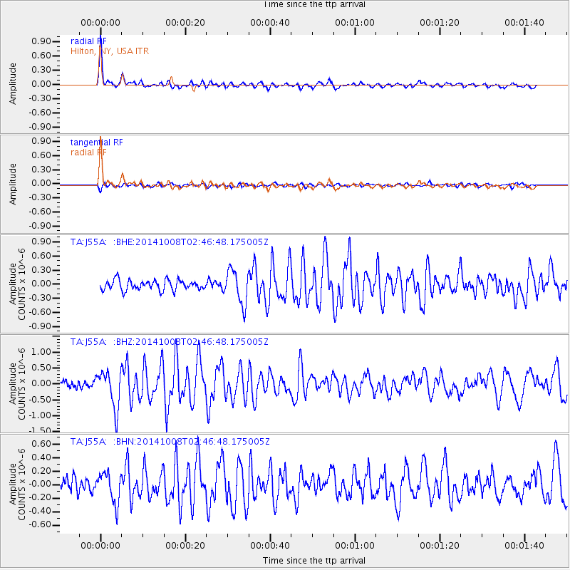
Signal To Noise
| Channel | StoN | STA | LTA |
| TA:J55A: :BHZ:20141008T02:46:48.175005Z | 5.2015376 | 5.916458E-7 | 1.13744406E-7 |
| TA:J55A: :BHN:20141008T02:46:48.175005Z | 1.6529841 | 2.251063E-7 | 1.3618177E-7 |
| TA:J55A: :BHE:20141008T02:46:48.175005Z | 3.4025528 | 3.5933326E-7 | 1.0560695E-7 |
| Arrivals |
| Ps | 5.4 SECOND |
| PpPs | 14 SECOND |
| PsPs/PpSs | 20 SECOND |


