You are here: Home > Network List > TA - USArray Transportable Network (new EarthScope stations) Stations List
> Station J60A Lant Hill Farm, Argyle, NY, USA > Earthquake Result Viewer
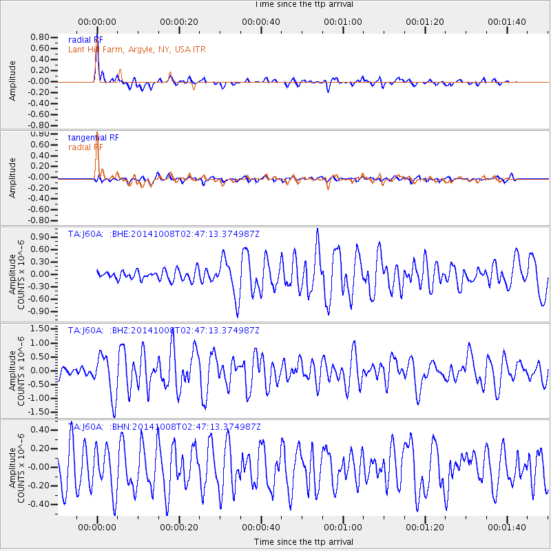
J60A Lant Hill Farm, Argyle, NY, USA - Earthquake Result Viewer

| Earthquake location: |
Gulf Of California |
| Earthquake latitude/longitude: |
23.8/-108.4 |
| Earthquake time(UTC): |
2014/10/08 (281) 02:40:54 GMT |
| Earthquake Depth: |
10 km |
| Earthquake Magnitude: |
6.2 MWP |
| Earthquake Catalog/Contributor: |
NEIC PDE/NEIC COMCAT |
|
| Network: |
TA USArray Transportable Network (new EarthScope stations) |
| Station: |
J60A Lant Hill Farm, Argyle, NY, USA |
| Lat/Lon: |
43.24 N/73.42 W |
| Elevation: |
265 m |
|
| Distance: |
34.7 deg |
| Az: |
47.443 deg |
| Baz: |
247.398 deg |
| Ray Param: |
0.07761499 |
| Estimated Moho Depth: |
20.75 km |
| Estimated Crust Vp/Vs: |
2.10 |
| Assumed Crust Vp: |
6.419 km/s |
| Estimated Crust Vs: |
3.064 km/s |
| Estimated Crust Poisson's Ratio: |
0.35 |
|
| Radial Match: |
82.59936 % |
| Radial Bump: |
317 |
| Transverse Match: |
58.79287 % |
| Transverse Bump: |
400 |
| SOD ConfigId: |
803114 |
| Insert Time: |
2014-10-22 03:12:10.225 +0000 |
| GWidth: |
2.5 |
| Max Bumps: |
400 |
| Tol: |
0.001 |
|
Signal To Noise
| Channel | StoN | STA | LTA |
| TA:J60A: :BHZ:20141008T02:47:13.374987Z | 5.661146 | 7.8418014E-7 | 1.3851968E-7 |
| TA:J60A: :BHN:20141008T02:47:13.374987Z | 1.5023482 | 2.407692E-7 | 1.6026192E-7 |
| TA:J60A: :BHE:20141008T02:47:13.374987Z | 4.296162 | 4.741114E-7 | 1.10356964E-7 |
| Arrivals |
| Ps | 3.8 SECOND |
| PpPs | 9.4 SECOND |
| PsPs/PpSs | 13 SECOND |


