You are here: Home > Network List > TA - USArray Transportable Network (new EarthScope stations) Stations List
> Station K54A Basiliko Farm, Boston, NY, USA > Earthquake Result Viewer
K54A Basiliko Farm, Boston, NY, USA - Earthquake Result Viewer
| Earthquake location: |
Gulf Of California |
| Earthquake latitude/longitude: |
23.8/-108.4 |
| Earthquake time(UTC): |
2014/10/08 (281) 02:40:54 GMT |
| Earthquake Depth: |
10 km |
| Earthquake Magnitude: |
6.2 MWP |
| Earthquake Catalog/Contributor: |
NEIC PDE/NEIC COMCAT |
|
| Network: |
TA USArray Transportable Network (new EarthScope stations) |
| Station: |
K54A Basiliko Farm, Boston, NY, USA |
| Lat/Lon: |
42.61 N/78.69 W |
| Elevation: |
465 m |
|
| Distance: |
30.9 deg |
| Az: |
45.456 deg |
| Baz: |
242.149 deg |
| Ray Param: |
0.0792076 |
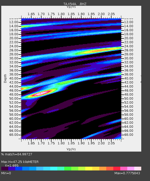
| Estimated Moho Depth: |
47.25 km |
| Estimated Crust Vp/Vs: |
1.70 |
| Assumed Crust Vp: |
6.419 km/s |
| Estimated Crust Vs: |
3.787 km/s |
| Estimated Crust Poisson's Ratio: |
0.23 |
|
| Radial Match: |
84.99727 % |
| Radial Bump: |
400 |
| Transverse Match: |
54.62111 % |
| Transverse Bump: |
400 |
| SOD ConfigId: |
803114 |
| Insert Time: |
2014-10-22 03:12:18.740 +0000 |
| GWidth: |
2.5 |
| Max Bumps: |
400 |
| Tol: |
0.001 |
|

Signal To Noise
| Channel | StoN | STA | LTA |
| TA:K54A: :BHZ:20141008T02:46:40.499987Z | 5.7987585 | 8.3098865E-7 | 1.4330459E-7 |
| TA:K54A: :BHN:20141008T02:46:40.499987Z | 1.6354995 | 1.9046196E-7 | 1.1645493E-7 |
| TA:K54A: :BHE:20141008T02:46:40.499987Z | 3.6728735 | 5.024902E-7 | 1.368112E-7 |
| Arrivals |
| Ps | 5.6 SECOND |
| PpPs | 18 SECOND |
| PsPs/PpSs | 24 SECOND |


