You are here: Home > Network List > TA - USArray Transportable Network (new EarthScope stations) Stations List
> Station K55A Perry, NY, USA > Earthquake Result Viewer
K55A Perry, NY, USA - Earthquake Result Viewer
| Earthquake location: |
Gulf Of California |
| Earthquake latitude/longitude: |
23.8/-108.4 |
| Earthquake time(UTC): |
2014/10/08 (281) 02:40:54 GMT |
| Earthquake Depth: |
10 km |
| Earthquake Magnitude: |
6.2 MWP |
| Earthquake Catalog/Contributor: |
NEIC PDE/NEIC COMCAT |
|
| Network: |
TA USArray Transportable Network (new EarthScope stations) |
| Station: |
K55A Perry, NY, USA |
| Lat/Lon: |
42.73 N/78.07 W |
| Elevation: |
482 m |
|
| Distance: |
31.4 deg |
| Az: |
45.663 deg |
| Baz: |
242.746 deg |
| Ray Param: |
0.07908654 |
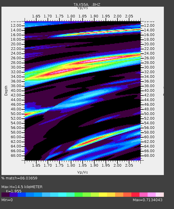
| Estimated Moho Depth: |
14.5 km |
| Estimated Crust Vp/Vs: |
1.96 |
| Assumed Crust Vp: |
6.419 km/s |
| Estimated Crust Vs: |
3.283 km/s |
| Estimated Crust Poisson's Ratio: |
0.32 |
|
| Radial Match: |
86.03659 % |
| Radial Bump: |
400 |
| Transverse Match: |
57.965523 % |
| Transverse Bump: |
400 |
| SOD ConfigId: |
803114 |
| Insert Time: |
2014-10-22 03:12:20.591 +0000 |
| GWidth: |
2.5 |
| Max Bumps: |
400 |
| Tol: |
0.001 |
|

Signal To Noise
| Channel | StoN | STA | LTA |
| TA:K55A: :BHZ:20141008T02:46:44.550005Z | 4.260934 | 6.3142386E-7 | 1.4818907E-7 |
| TA:K55A: :BHN:20141008T02:46:44.550005Z | 2.8535757 | 2.7861884E-7 | 9.763849E-8 |
| TA:K55A: :BHE:20141008T02:46:44.550005Z | 3.4234653 | 3.9142017E-7 | 1.143345E-7 |
| Arrivals |
| Ps | 2.3 SECOND |
| PpPs | 6.2 SECOND |
| PsPs/PpSs | 8.5 SECOND |


