You are here: Home > Network List > AK - Alaska Regional Network Stations List
> Station MDM Murphy Dome > Earthquake Result Viewer
MDM Murphy Dome - Earthquake Result Viewer
| Earthquake location: |
Southeast Of Honshu, Japan |
| Earthquake latitude/longitude: |
31.6/140.2 |
| Earthquake time(UTC): |
2015/05/02 (122) 16:50:46 GMT |
| Earthquake Depth: |
32 km |
| Earthquake Magnitude: |
5.7 MB |
| Earthquake Catalog/Contributor: |
NEIC PDE/NEIC ALERT |
|
| Network: |
AK Alaska Regional Network |
| Station: |
MDM Murphy Dome |
| Lat/Lon: |
64.96 N/148.23 W |
| Elevation: |
634 m |
|
| Distance: |
54.1 deg |
| Az: |
29.905 deg |
| Baz: |
268.457 deg |
| Ray Param: |
0.0656029 |
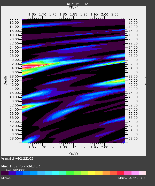
| Estimated Moho Depth: |
32.75 km |
| Estimated Crust Vp/Vs: |
1.69 |
| Assumed Crust Vp: |
6.566 km/s |
| Estimated Crust Vs: |
3.897 km/s |
| Estimated Crust Poisson's Ratio: |
0.23 |
|
| Radial Match: |
92.22102 % |
| Radial Bump: |
323 |
| Transverse Match: |
50.894524 % |
| Transverse Bump: |
400 |
| SOD ConfigId: |
7422571 |
| Insert Time: |
2019-04-18 15:13:31.000 +0000 |
| GWidth: |
2.5 |
| Max Bumps: |
400 |
| Tol: |
0.001 |
|

Signal To Noise
| Channel | StoN | STA | LTA |
| AK:MDM: :BHZ:20150502T16:59:38.008008Z | 3.0584826 | 1.6585129E-7 | 5.4226657E-8 |
| AK:MDM: :BHN:20150502T16:59:38.008008Z | 0.5677239 | 6.312013E-8 | 1.1118104E-7 |
| AK:MDM: :BHE:20150502T16:59:38.008008Z | 1.210087 | 8.0683506E-8 | 6.6675796E-8 |
| Arrivals |
| Ps | 3.6 SECOND |
| PpPs | 13 SECOND |
| PsPs/PpSs | 16 SECOND |


