You are here: Home > Network List > TA - USArray Transportable Network (new EarthScope stations) Stations List
> Station K57A Scipio Center, NY, USA > Earthquake Result Viewer
K57A Scipio Center, NY, USA - Earthquake Result Viewer
| Earthquake location: |
Gulf Of California |
| Earthquake latitude/longitude: |
23.8/-108.4 |
| Earthquake time(UTC): |
2014/10/08 (281) 02:40:54 GMT |
| Earthquake Depth: |
10 km |
| Earthquake Magnitude: |
6.2 MWP |
| Earthquake Catalog/Contributor: |
NEIC PDE/NEIC COMCAT |
|
| Network: |
TA USArray Transportable Network (new EarthScope stations) |
| Station: |
K57A Scipio Center, NY, USA |
| Lat/Lon: |
42.73 N/76.52 W |
| Elevation: |
408 m |
|
| Distance: |
32.4 deg |
| Az: |
46.618 deg |
| Baz: |
244.607 deg |
| Ray Param: |
0.078667894 |
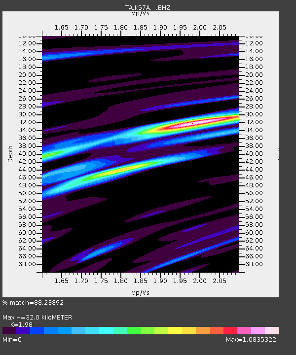
| Estimated Moho Depth: |
32.0 km |
| Estimated Crust Vp/Vs: |
1.98 |
| Assumed Crust Vp: |
6.476 km/s |
| Estimated Crust Vs: |
3.271 km/s |
| Estimated Crust Poisson's Ratio: |
0.33 |
|
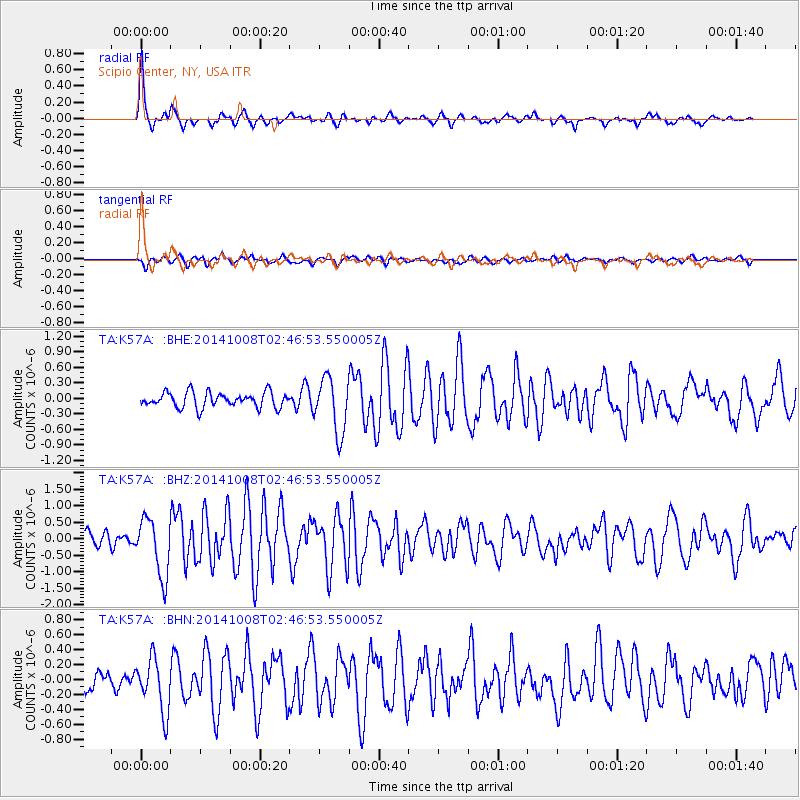
| Radial Match: |
88.23892 % |
| Radial Bump: |
318 |
| Transverse Match: |
63.76755 % |
| Transverse Bump: |
400 |
| SOD ConfigId: |
803114 |
| Insert Time: |
2014-10-22 03:12:25.156 +0000 |
| GWidth: |
2.5 |
| Max Bumps: |
400 |
| Tol: |
0.001 |
|
Signal To Noise
| Channel | StoN | STA | LTA |
| TA:K57A: :BHZ:20141008T02:46:53.550005Z | 5.0109115 | 8.778848E-7 | 1.7519463E-7 |
| TA:K57A: :BHN:20141008T02:46:53.550005Z | 3.0034068 | 3.56842E-7 | 1.18812416E-7 |
| TA:K57A: :BHE:20141008T02:46:53.550005Z | 3.6419423 | 5.3196317E-7 | 1.4606579E-7 |
| Arrivals |
| Ps | 5.2 SECOND |
| PpPs | 14 SECOND |
| PsPs/PpSs | 19 SECOND |


