You are here: Home > Network List > TA - USArray Transportable Network (new EarthScope stations) Stations List
> Station K62A Royalston, MA, USA > Earthquake Result Viewer
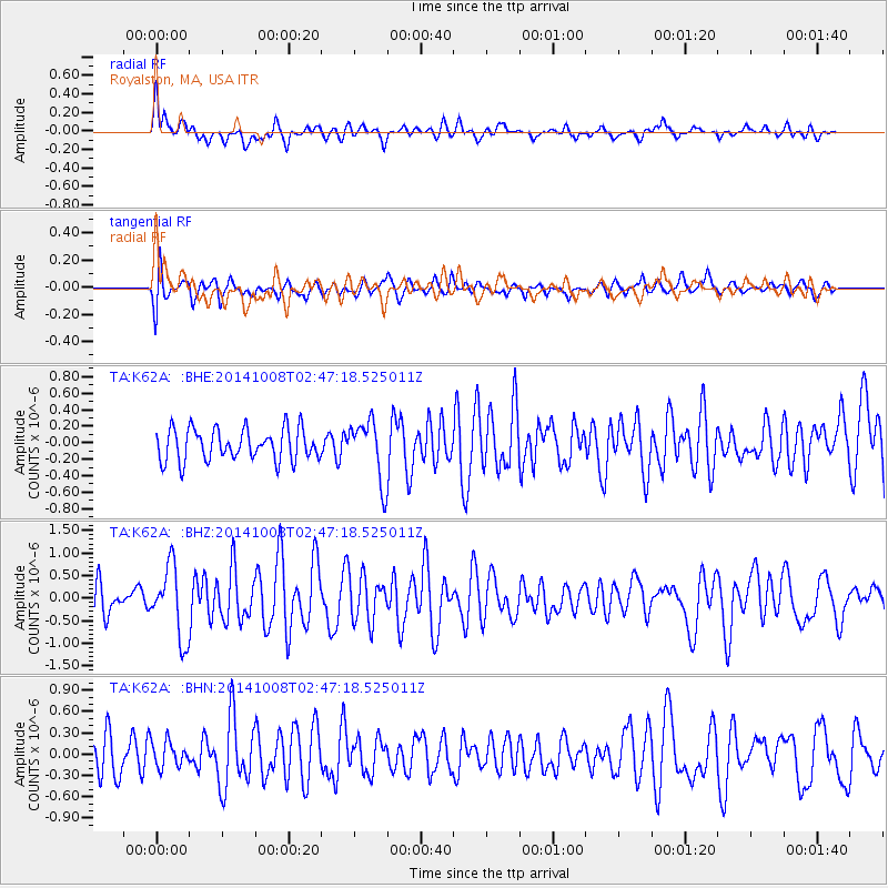
K62A Royalston, MA, USA - Earthquake Result Viewer
*The percent match for this event was below the threshold and hence no stack was calculated.
| Earthquake location: |
Gulf Of California |
| Earthquake latitude/longitude: |
23.8/-108.4 |
| Earthquake time(UTC): |
2014/10/08 (281) 02:40:54 GMT |
| Earthquake Depth: |
10 km |
| Earthquake Magnitude: |
6.2 MWP |
| Earthquake Catalog/Contributor: |
NEIC PDE/NEIC COMCAT |
|
| Network: |
TA USArray Transportable Network (new EarthScope stations) |
| Station: |
K62A Royalston, MA, USA |
| Lat/Lon: |
42.67 N/72.23 W |
| Elevation: |
289 m |
|
| Distance: |
35.3 deg |
| Az: |
48.94 deg |
| Baz: |
249.43 deg |
| Ray Param: |
$rayparam |
*The percent match for this event was below the threshold and hence was not used in the summary stack. |
|
| Radial Match: |
77.78889 % |
| Radial Bump: |
400 |
| Transverse Match: |
67.55271 % |
| Transverse Bump: |
400 |
| SOD ConfigId: |
803114 |
| Insert Time: |
2014-10-22 03:12:37.056 +0000 |
| GWidth: |
2.5 |
| Max Bumps: |
400 |
| Tol: |
0.001 |
|
Signal To Noise
| Channel | StoN | STA | LTA |
| TA:K62A: :BHZ:20141008T02:47:18.525011Z | 2.3196583 | 7.8907584E-7 | 3.40169E-7 |
| TA:K62A: :BHN:20141008T02:47:18.525011Z | 0.7340669 | 1.788586E-7 | 2.4365437E-7 |
| TA:K62A: :BHE:20141008T02:47:18.525011Z | 1.8926058 | 3.6384066E-7 | 1.9224323E-7 |
| Arrivals |
| Ps | |
| PpPs | |
| PsPs/PpSs | |


