You are here: Home > Network List > TA - USArray Transportable Network (new EarthScope stations) Stations List
> Station L60A Shokan, NY, USA > Earthquake Result Viewer
L60A Shokan, NY, USA - Earthquake Result Viewer
| Earthquake location: |
Gulf Of California |
| Earthquake latitude/longitude: |
23.8/-108.4 |
| Earthquake time(UTC): |
2014/10/08 (281) 02:40:54 GMT |
| Earthquake Depth: |
10 km |
| Earthquake Magnitude: |
6.2 MWP |
| Earthquake Catalog/Contributor: |
NEIC PDE/NEIC COMCAT |
|
| Network: |
TA USArray Transportable Network (new EarthScope stations) |
| Station: |
L60A Shokan, NY, USA |
| Lat/Lon: |
41.99 N/74.22 W |
| Elevation: |
388 m |
|
| Distance: |
33.7 deg |
| Az: |
49.113 deg |
| Baz: |
248.239 deg |
| Ray Param: |
0.07810456 |
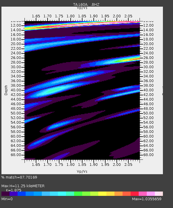
| Estimated Moho Depth: |
11.25 km |
| Estimated Crust Vp/Vs: |
1.88 |
| Assumed Crust Vp: |
6.283 km/s |
| Estimated Crust Vs: |
3.351 km/s |
| Estimated Crust Poisson's Ratio: |
0.30 |
|
| Radial Match: |
87.70169 % |
| Radial Bump: |
317 |
| Transverse Match: |
60.579247 % |
| Transverse Bump: |
400 |
| SOD ConfigId: |
803114 |
| Insert Time: |
2014-10-22 03:12:54.552 +0000 |
| GWidth: |
2.5 |
| Max Bumps: |
400 |
| Tol: |
0.001 |
|
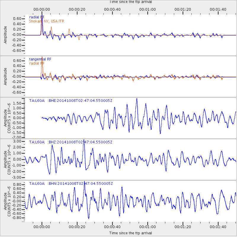
Signal To Noise
| Channel | StoN | STA | LTA |
| TA:L60A: :BHZ:20141008T02:47:04.550005Z | 3.156648 | 1.096333E-6 | 3.4730925E-7 |
| TA:L60A: :BHN:20141008T02:47:04.550005Z | 1.0619805 | 2.2367009E-7 | 2.10616E-7 |
| TA:L60A: :BHE:20141008T02:47:04.550005Z | 2.4730875 | 5.416418E-7 | 2.1901438E-7 |
| Arrivals |
| Ps | 1.7 SECOND |
| PpPs | 4.8 SECOND |
| PsPs/PpSs | 6.5 SECOND |


