You are here: Home > Network List > TA - USArray Transportable Network (new EarthScope stations) Stations List
> Station N57A Milroy, PA, USA > Earthquake Result Viewer
N57A Milroy, PA, USA - Earthquake Result Viewer
| Earthquake location: |
Gulf Of California |
| Earthquake latitude/longitude: |
23.8/-108.4 |
| Earthquake time(UTC): |
2014/10/08 (281) 02:40:54 GMT |
| Earthquake Depth: |
10 km |
| Earthquake Magnitude: |
6.2 MWP |
| Earthquake Catalog/Contributor: |
NEIC PDE/NEIC COMCAT |
|
| Network: |
TA USArray Transportable Network (new EarthScope stations) |
| Station: |
N57A Milroy, PA, USA |
| Lat/Lon: |
40.76 N/77.55 W |
| Elevation: |
306 m |
|
| Distance: |
30.9 deg |
| Az: |
49.429 deg |
| Baz: |
246.314 deg |
| Ray Param: |
0.079217166 |
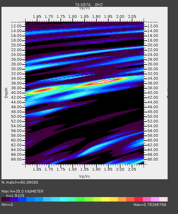
| Estimated Moho Depth: |
35.0 km |
| Estimated Crust Vp/Vs: |
1.93 |
| Assumed Crust Vp: |
6.121 km/s |
| Estimated Crust Vs: |
3.167 km/s |
| Estimated Crust Poisson's Ratio: |
0.32 |
|
| Radial Match: |
90.89065 % |
| Radial Bump: |
273 |
| Transverse Match: |
63.327637 % |
| Transverse Bump: |
400 |
| SOD ConfigId: |
803114 |
| Insert Time: |
2014-10-22 03:13:34.479 +0000 |
| GWidth: |
2.5 |
| Max Bumps: |
400 |
| Tol: |
0.001 |
|
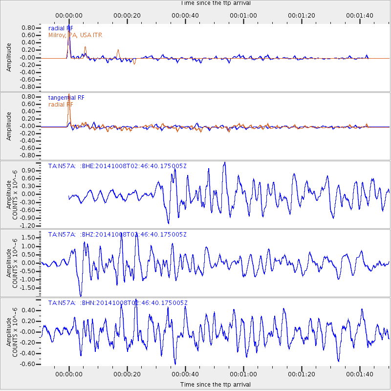
Signal To Noise
| Channel | StoN | STA | LTA |
| TA:N57A: :BHZ:20141008T02:46:40.175005Z | 8.117101 | 8.933474E-7 | 1.1005745E-7 |
| TA:N57A: :BHN:20141008T02:46:40.175005Z | 1.904139 | 1.6872474E-7 | 8.860946E-8 |
| TA:N57A: :BHE:20141008T02:46:40.175005Z | 3.8340144 | 4.9212366E-7 | 1.2835729E-7 |
| Arrivals |
| Ps | 5.7 SECOND |
| PpPs | 16 SECOND |
| PsPs/PpSs | 21 SECOND |


