You are here: Home > Network List > TA - USArray Transportable Network (new EarthScope stations) Stations List
> Station O59A Robesonia, PA, USA > Earthquake Result Viewer
O59A Robesonia, PA, USA - Earthquake Result Viewer
| Earthquake location: |
Gulf Of California |
| Earthquake latitude/longitude: |
23.8/-108.4 |
| Earthquake time(UTC): |
2014/10/08 (281) 02:40:54 GMT |
| Earthquake Depth: |
10 km |
| Earthquake Magnitude: |
6.2 MWP |
| Earthquake Catalog/Contributor: |
NEIC PDE/NEIC COMCAT |
|
| Network: |
TA USArray Transportable Network (new EarthScope stations) |
| Station: |
O59A Robesonia, PA, USA |
| Lat/Lon: |
40.31 N/76.19 W |
| Elevation: |
334 m |
|
| Distance: |
31.7 deg |
| Az: |
50.988 deg |
| Baz: |
248.53 deg |
| Ray Param: |
0.07898016 |
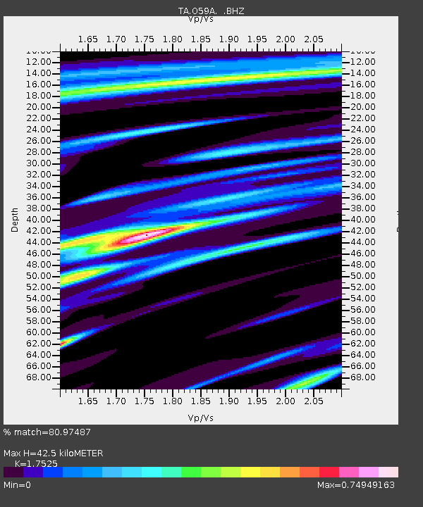
| Estimated Moho Depth: |
42.5 km |
| Estimated Crust Vp/Vs: |
1.75 |
| Assumed Crust Vp: |
6.121 km/s |
| Estimated Crust Vs: |
3.492 km/s |
| Estimated Crust Poisson's Ratio: |
0.26 |
|
| Radial Match: |
80.97487 % |
| Radial Bump: |
341 |
| Transverse Match: |
78.58165 % |
| Transverse Bump: |
400 |
| SOD ConfigId: |
803114 |
| Insert Time: |
2014-10-22 03:13:54.324 +0000 |
| GWidth: |
2.5 |
| Max Bumps: |
400 |
| Tol: |
0.001 |
|

Signal To Noise
| Channel | StoN | STA | LTA |
| TA:O59A: :BHZ:20141008T02:46:47.124987Z | 5.075009 | 6.9431616E-7 | 1.3681084E-7 |
| TA:O59A: :BHN:20141008T02:46:47.124987Z | 1.4316701 | 1.8882426E-7 | 1.3189091E-7 |
| TA:O59A: :BHE:20141008T02:46:47.124987Z | 4.3250413 | 5.305348E-7 | 1.2266584E-7 |
| Arrivals |
| Ps | 5.6 SECOND |
| PpPs | 18 SECOND |
| PsPs/PpSs | 23 SECOND |


