You are here: Home > Network List > TA - USArray Transportable Network (new EarthScope stations) Stations List
> Station O61A Allentown, NJ, USA > Earthquake Result Viewer
O61A Allentown, NJ, USA - Earthquake Result Viewer
| Earthquake location: |
Gulf Of California |
| Earthquake latitude/longitude: |
23.8/-108.4 |
| Earthquake time(UTC): |
2014/10/08 (281) 02:40:54 GMT |
| Earthquake Depth: |
10 km |
| Earthquake Magnitude: |
6.2 MWP |
| Earthquake Catalog/Contributor: |
NEIC PDE/NEIC COMCAT |
|
| Network: |
TA USArray Transportable Network (new EarthScope stations) |
| Station: |
O61A Allentown, NJ, USA |
| Lat/Lon: |
40.09 N/74.55 W |
| Elevation: |
38 m |
|
| Distance: |
32.8 deg |
| Az: |
52.19 deg |
| Baz: |
250.597 deg |
| Ray Param: |
0.07851411 |
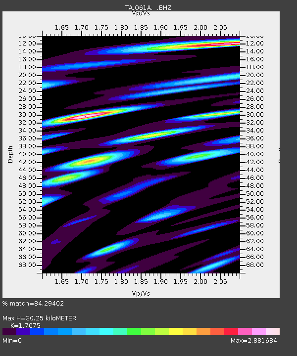
| Estimated Moho Depth: |
30.25 km |
| Estimated Crust Vp/Vs: |
1.71 |
| Assumed Crust Vp: |
6.283 km/s |
| Estimated Crust Vs: |
3.68 km/s |
| Estimated Crust Poisson's Ratio: |
0.24 |
|
| Radial Match: |
84.29402 % |
| Radial Bump: |
400 |
| Transverse Match: |
67.36951 % |
| Transverse Bump: |
400 |
| SOD ConfigId: |
803114 |
| Insert Time: |
2014-10-22 03:13:59.172 +0000 |
| GWidth: |
2.5 |
| Max Bumps: |
400 |
| Tol: |
0.001 |
|

Signal To Noise
| Channel | StoN | STA | LTA |
| TA:O61A: :BHZ:20141008T02:46:56.724993Z | 4.653897 | 9.100453E-7 | 1.955448E-7 |
| TA:O61A: :BHN:20141008T02:46:56.724993Z | 1.6186639 | 4.7248355E-7 | 2.9189727E-7 |
| TA:O61A: :BHE:20141008T02:46:56.724993Z | 1.9527637 | 8.5623583E-7 | 4.3847385E-7 |
| Arrivals |
| Ps | 3.7 SECOND |
| PpPs | 12 SECOND |
| PsPs/PpSs | 16 SECOND |


