You are here: Home > Network List > TA - USArray Transportable Network (new EarthScope stations) Stations List
> Station P57A Homestead Farm, Martinsburg, WV, USA > Earthquake Result Viewer
P57A Homestead Farm, Martinsburg, WV, USA - Earthquake Result Viewer
| Earthquake location: |
Gulf Of California |
| Earthquake latitude/longitude: |
23.8/-108.4 |
| Earthquake time(UTC): |
2014/10/08 (281) 02:40:54 GMT |
| Earthquake Depth: |
10 km |
| Earthquake Magnitude: |
6.2 MWP |
| Earthquake Catalog/Contributor: |
NEIC PDE/NEIC COMCAT |
|
| Network: |
TA USArray Transportable Network (new EarthScope stations) |
| Station: |
P57A Homestead Farm, Martinsburg, WV, USA |
| Lat/Lon: |
39.48 N/78.01 W |
| Elevation: |
191 m |
|
| Distance: |
30.1 deg |
| Az: |
51.464 deg |
| Baz: |
247.772 deg |
| Ray Param: |
0.07943305 |
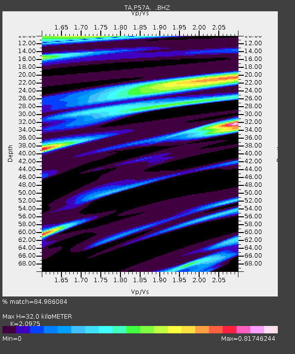
| Estimated Moho Depth: |
32.0 km |
| Estimated Crust Vp/Vs: |
2.10 |
| Assumed Crust Vp: |
6.159 km/s |
| Estimated Crust Vs: |
2.936 km/s |
| Estimated Crust Poisson's Ratio: |
0.35 |
|
| Radial Match: |
84.986084 % |
| Radial Bump: |
400 |
| Transverse Match: |
70.79489 % |
| Transverse Bump: |
400 |
| SOD ConfigId: |
803114 |
| Insert Time: |
2014-10-22 03:14:02.209 +0000 |
| GWidth: |
2.5 |
| Max Bumps: |
400 |
| Tol: |
0.001 |
|
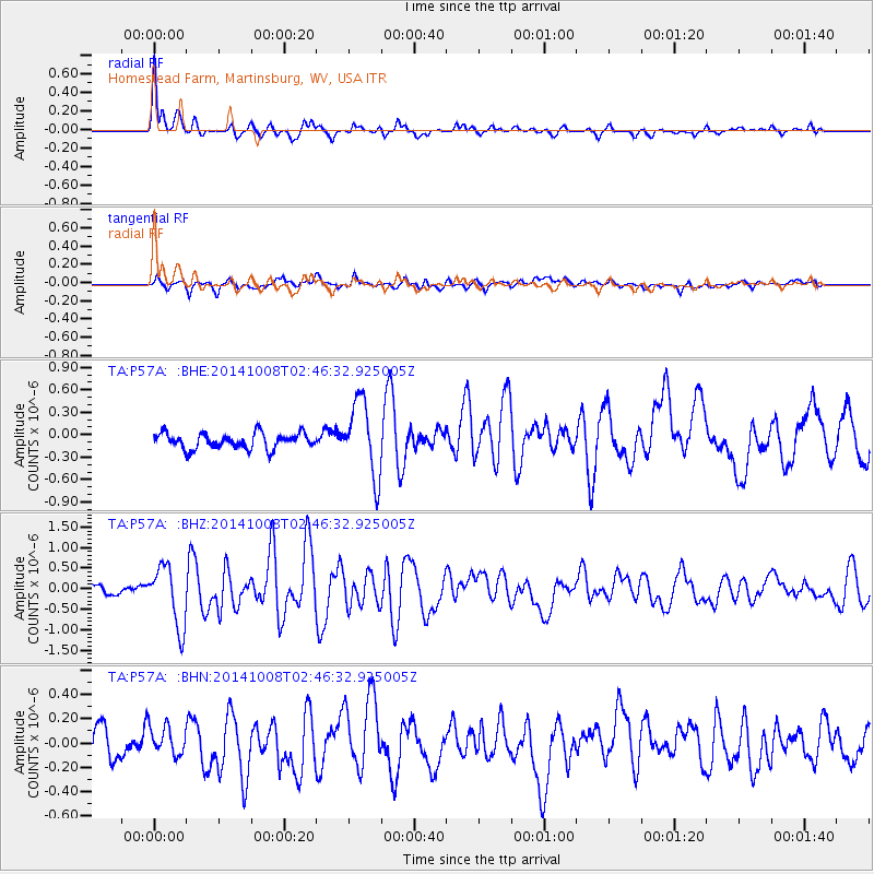
Signal To Noise
| Channel | StoN | STA | LTA |
| TA:P57A: :BHZ:20141008T02:46:32.925005Z | 5.72555 | 7.3975144E-7 | 1.2920181E-7 |
| TA:P57A: :BHN:20141008T02:46:32.925005Z | 1.1099647 | 1.18198386E-7 | 1.06488415E-7 |
| TA:P57A: :BHE:20141008T02:46:32.925005Z | 4.799841 | 5.040969E-7 | 1.0502366E-7 |
| Arrivals |
| Ps | 6.1 SECOND |
| PpPs | 15 SECOND |
| PsPs/PpSs | 21 SECOND |


