You are here: Home > Network List > TA - USArray Transportable Network (new EarthScope stations) Stations List
> Station Q60A Greensboro, MD, USA > Earthquake Result Viewer
Q60A Greensboro, MD, USA - Earthquake Result Viewer
| Earthquake location: |
Gulf Of California |
| Earthquake latitude/longitude: |
23.8/-108.4 |
| Earthquake time(UTC): |
2014/10/08 (281) 02:40:54 GMT |
| Earthquake Depth: |
10 km |
| Earthquake Magnitude: |
6.2 MWP |
| Earthquake Catalog/Contributor: |
NEIC PDE/NEIC COMCAT |
|
| Network: |
TA USArray Transportable Network (new EarthScope stations) |
| Station: |
Q60A Greensboro, MD, USA |
| Lat/Lon: |
39.00 N/75.84 W |
| Elevation: |
14 m |
|
| Distance: |
31.5 deg |
| Az: |
53.507 deg |
| Baz: |
250.895 deg |
| Ray Param: |
0.07906346 |
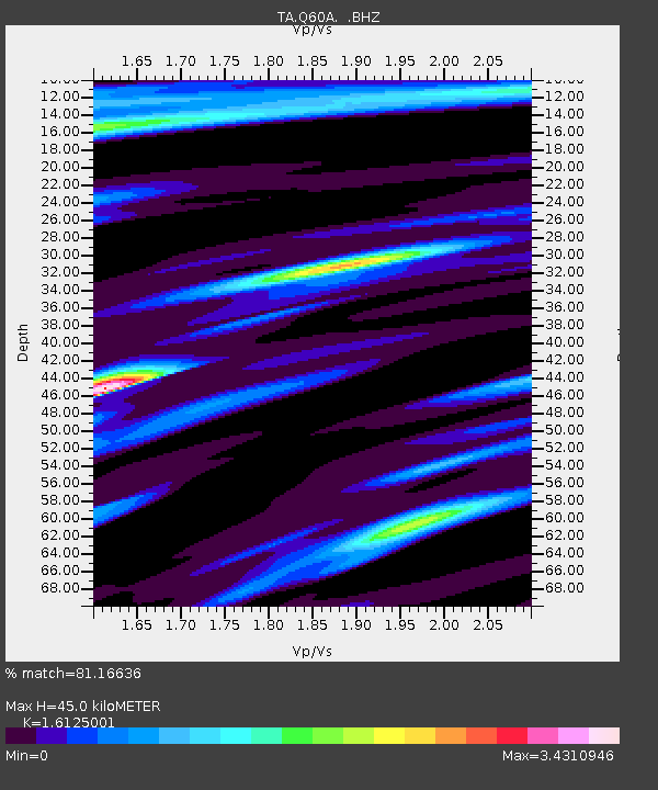
| Estimated Moho Depth: |
45.0 km |
| Estimated Crust Vp/Vs: |
1.61 |
| Assumed Crust Vp: |
6.287 km/s |
| Estimated Crust Vs: |
3.899 km/s |
| Estimated Crust Poisson's Ratio: |
0.19 |
|
| Radial Match: |
81.16636 % |
| Radial Bump: |
400 |
| Transverse Match: |
68.78241 % |
| Transverse Bump: |
400 |
| SOD ConfigId: |
803114 |
| Insert Time: |
2014-10-22 03:14:31.841 +0000 |
| GWidth: |
2.5 |
| Max Bumps: |
400 |
| Tol: |
0.001 |
|

Signal To Noise
| Channel | StoN | STA | LTA |
| TA:Q60A: :BHZ:20141008T02:46:45.324999Z | 3.5972493 | 1.2514365E-6 | 3.4788707E-7 |
| TA:Q60A: :BHN:20141008T02:46:45.324999Z | 1.2551128 | 4.8316457E-7 | 3.849571E-7 |
| TA:Q60A: :BHE:20141008T02:46:45.324999Z | 1.6476632 | 1.079271E-6 | 6.5503133E-7 |
| Arrivals |
| Ps | 4.8 SECOND |
| PpPs | 17 SECOND |
| PsPs/PpSs | 22 SECOND |


