You are here: Home > Network List > WI - West Indies IPGP Network Stations List
> Station BIM Morne Bigot, Anses d'Arlets, Martinique > Earthquake Result Viewer
BIM Morne Bigot, Anses d'Arlets, Martinique - Earthquake Result Viewer
| Earthquake location: |
Gulf Of California |
| Earthquake latitude/longitude: |
23.8/-108.4 |
| Earthquake time(UTC): |
2014/10/08 (281) 02:40:54 GMT |
| Earthquake Depth: |
10 km |
| Earthquake Magnitude: |
6.2 MWP |
| Earthquake Catalog/Contributor: |
NEIC PDE/NEIC COMCAT |
|
| Network: |
WI West Indies IPGP Network |
| Station: |
BIM Morne Bigot, Anses d'Arlets, Martinique |
| Lat/Lon: |
14.52 N/61.07 W |
| Elevation: |
391 m |
|
| Distance: |
45.5 deg |
| Az: |
92.837 deg |
| Baz: |
289.18 deg |
| Ray Param: |
0.071235776 |
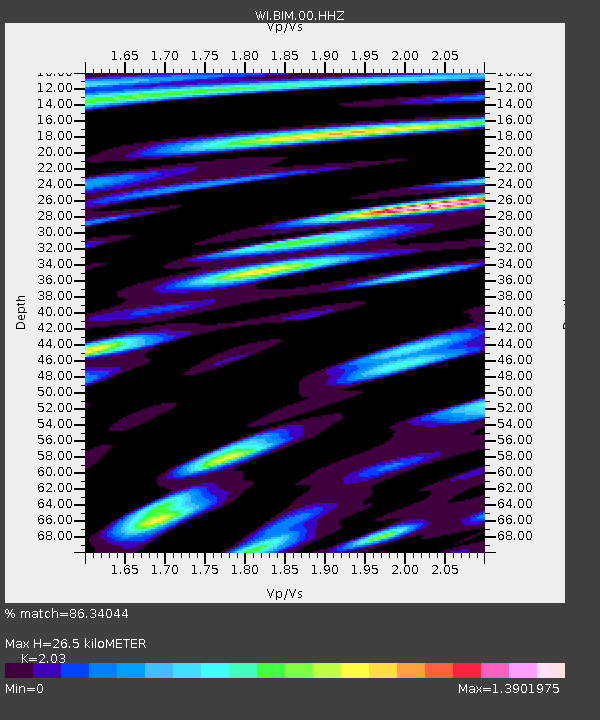
| Estimated Moho Depth: |
26.5 km |
| Estimated Crust Vp/Vs: |
2.03 |
| Assumed Crust Vp: |
5.88 km/s |
| Estimated Crust Vs: |
2.897 km/s |
| Estimated Crust Poisson's Ratio: |
0.34 |
|
| Radial Match: |
86.34044 % |
| Radial Bump: |
400 |
| Transverse Match: |
64.83365 % |
| Transverse Bump: |
400 |
| SOD ConfigId: |
803114 |
| Insert Time: |
2014-10-22 03:15:26.227 +0000 |
| GWidth: |
2.5 |
| Max Bumps: |
400 |
| Tol: |
0.001 |
|
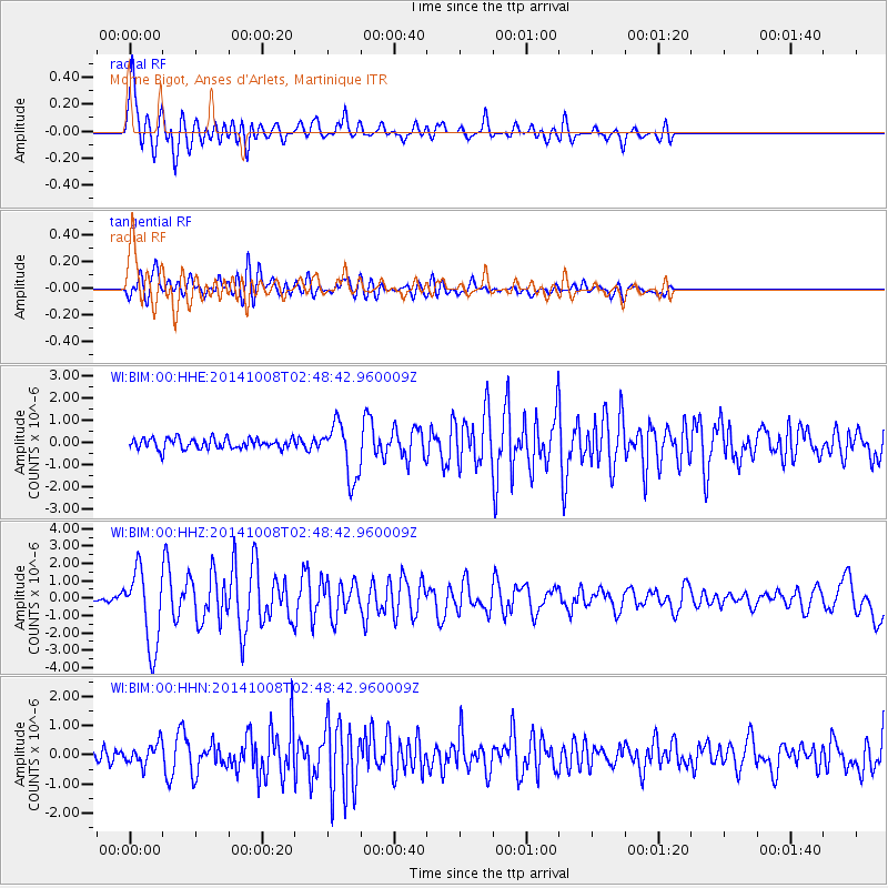
Signal To Noise
| Channel | StoN | STA | LTA |
| WI:BIM:00:HHZ:20141008T02:48:42.960009Z | 11.066936 | 2.200292E-6 | 1.9881675E-7 |
| WI:BIM:00:HHN:20141008T02:48:42.960009Z | 1.497481 | 3.5160994E-7 | 2.3480094E-7 |
| WI:BIM:00:HHE:20141008T02:48:42.960009Z | 5.2215776 | 1.2276805E-6 | 2.3511679E-7 |
| Arrivals |
| Ps | 4.9 SECOND |
| PpPs | 13 SECOND |
| PsPs/PpSs | 18 SECOND |


