You are here: Home > Network List > WI - West Indies IPGP Network Stations List
> Station DHS Morne Mazeau - Deshaies, Guadeloupe > Earthquake Result Viewer
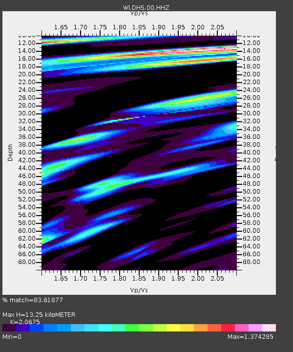
DHS Morne Mazeau - Deshaies, Guadeloupe - Earthquake Result Viewer
| Earthquake location: |
Gulf Of California |
| Earthquake latitude/longitude: |
23.8/-108.4 |
| Earthquake time(UTC): |
2014/10/08 (281) 02:40:54 GMT |
| Earthquake Depth: |
10 km |
| Earthquake Magnitude: |
6.2 MWP |
| Earthquake Catalog/Contributor: |
NEIC PDE/NEIC COMCAT |
|
| Network: |
WI West Indies IPGP Network |
| Station: |
DHS Morne Mazeau - Deshaies, Guadeloupe |
| Lat/Lon: |
16.27 N/61.77 W |
| Elevation: |
618 m |
|
| Distance: |
44.3 deg |
| Az: |
90.792 deg |
| Baz: |
287.547 deg |
| Ray Param: |
0.07199387 |
| Estimated Moho Depth: |
13.25 km |
| Estimated Crust Vp/Vs: |
2.07 |
| Assumed Crust Vp: |
6.048 km/s |
| Estimated Crust Vs: |
2.925 km/s |
| Estimated Crust Poisson's Ratio: |
0.35 |
|
| Radial Match: |
83.61877 % |
| Radial Bump: |
400 |
| Transverse Match: |
65.20541 % |
| Transverse Bump: |
400 |
| SOD ConfigId: |
803114 |
| Insert Time: |
2014-10-22 03:15:31.203 +0000 |
| GWidth: |
2.5 |
| Max Bumps: |
400 |
| Tol: |
0.001 |
|

Signal To Noise
| Channel | StoN | STA | LTA |
| WI:DHS:00:HHZ:20141008T02:48:33.499987Z | 9.366877 | 2.1938758E-6 | 2.3421636E-7 |
| WI:DHS:00:HHN:20141008T02:48:33.499987Z | 2.3840332 | 7.461733E-7 | 3.1298782E-7 |
| WI:DHS:00:HHE:20141008T02:48:33.499987Z | 2.9717805 | 1.0977291E-6 | 3.693843E-7 |
| Arrivals |
| Ps | 2.5 SECOND |
| PpPs | 6.4 SECOND |
| PsPs/PpSs | 8.9 SECOND |


