You are here: Home > Network List > WI - West Indies IPGP Network Stations List
> Station TDBA Terre de Bas, Les Saintes > Earthquake Result Viewer
TDBA Terre de Bas, Les Saintes - Earthquake Result Viewer
| Earthquake location: |
Gulf Of California |
| Earthquake latitude/longitude: |
23.8/-108.4 |
| Earthquake time(UTC): |
2014/10/08 (281) 02:40:54 GMT |
| Earthquake Depth: |
10 km |
| Earthquake Magnitude: |
6.2 MWP |
| Earthquake Catalog/Contributor: |
NEIC PDE/NEIC COMCAT |
|
| Network: |
WI West Indies IPGP Network |
| Station: |
TDBA Terre de Bas, Les Saintes |
| Lat/Lon: |
15.85 N/61.64 W |
| Elevation: |
176 m |
|
| Distance: |
44.6 deg |
| Az: |
91.303 deg |
| Baz: |
287.948 deg |
| Ray Param: |
0.07184286 |
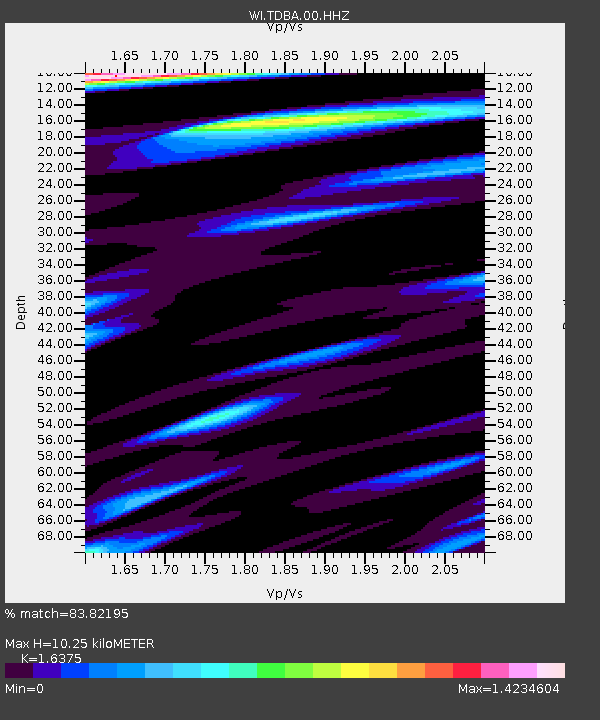
| Estimated Moho Depth: |
10.25 km |
| Estimated Crust Vp/Vs: |
1.64 |
| Assumed Crust Vp: |
5.88 km/s |
| Estimated Crust Vs: |
3.591 km/s |
| Estimated Crust Poisson's Ratio: |
0.20 |
|
| Radial Match: |
83.82195 % |
| Radial Bump: |
400 |
| Transverse Match: |
77.98426 % |
| Transverse Bump: |
400 |
| SOD ConfigId: |
803114 |
| Insert Time: |
2014-10-22 03:15:46.241 +0000 |
| GWidth: |
2.5 |
| Max Bumps: |
400 |
| Tol: |
0.001 |
|

Signal To Noise
| Channel | StoN | STA | LTA |
| WI:TDBA:00:HHZ:20141008T02:48:35.449999Z | 11.927234 | 2.8438844E-6 | 2.384362E-7 |
| WI:TDBA:00:HHN:20141008T02:48:35.449999Z | 1.5384474 | 6.8561593E-7 | 4.4565442E-7 |
| WI:TDBA:00:HHE:20141008T02:48:35.449999Z | 4.5083303 | 1.3413002E-6 | 2.9751595E-7 |
| Arrivals |
| Ps | 1.2 SECOND |
| PpPs | 4.3 SECOND |
| PsPs/PpSs | 5.5 SECOND |


