You are here: Home > Network List > TM - Thai Seismic Monitoring Network Stations List
> Station UBPT UBPT Phase1 > Earthquake Result Viewer
UBPT UBPT Phase1 - Earthquake Result Viewer
| Earthquake location: |
Southeast Of Honshu, Japan |
| Earthquake latitude/longitude: |
31.6/140.2 |
| Earthquake time(UTC): |
2015/05/02 (122) 16:50:46 GMT |
| Earthquake Depth: |
32 km |
| Earthquake Magnitude: |
5.7 MB |
| Earthquake Catalog/Contributor: |
NEIC PDE/NEIC ALERT |
|
| Network: |
TM Thai Seismic Monitoring Network |
| Station: |
UBPT UBPT Phase1 |
| Lat/Lon: |
15.28 N/105.47 E |
| Elevation: |
120 m |
|
| Distance: |
35.5 deg |
| Az: |
250.901 deg |
| Baz: |
56.671 deg |
| Ray Param: |
0.077104375 |
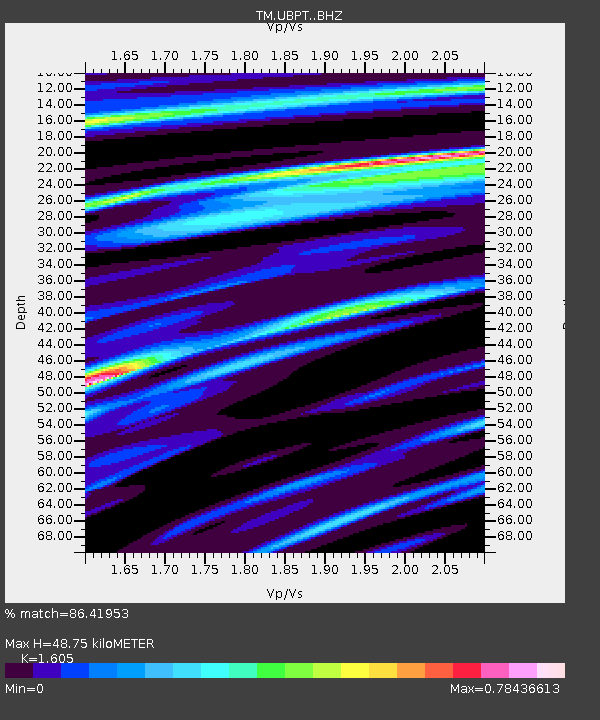
| Estimated Moho Depth: |
48.75 km |
| Estimated Crust Vp/Vs: |
1.61 |
| Assumed Crust Vp: |
6.444 km/s |
| Estimated Crust Vs: |
4.015 km/s |
| Estimated Crust Poisson's Ratio: |
0.18 |
|
| Radial Match: |
86.41953 % |
| Radial Bump: |
400 |
| Transverse Match: |
76.41054 % |
| Transverse Bump: |
400 |
| SOD ConfigId: |
7422571 |
| Insert Time: |
2019-04-18 15:18:47.655 +0000 |
| GWidth: |
2.5 |
| Max Bumps: |
400 |
| Tol: |
0.001 |
|

Signal To Noise
| Channel | StoN | STA | LTA |
| TM:UBPT: :BHZ:20150502T16:57:10.440015Z | 4.3754344 | 3.779778E-7 | 8.638635E-8 |
| TM:UBPT: :BHN:20150502T16:57:10.440015Z | 2.8052852 | 1.5443972E-7 | 5.5053125E-8 |
| TM:UBPT: :BHE:20150502T16:57:10.440015Z | 2.3623254 | 1.11942E-7 | 4.7386358E-8 |
| Arrivals |
| Ps | 5.0 SECOND |
| PpPs | 18 SECOND |
| PsPs/PpSs | 23 SECOND |


