You are here: Home > Network List > BK - Berkeley Digital Seismograph Network Stations List
> Station HUMO Hull Mountain, OR > Earthquake Result Viewer
HUMO Hull Mountain, OR - Earthquake Result Viewer
| Earthquake location: |
Southern East Pacific Rise |
| Earthquake latitude/longitude: |
-32.1/-110.8 |
| Earthquake time(UTC): |
2014/10/09 (282) 02:14:32 GMT |
| Earthquake Depth: |
16 km |
| Earthquake Magnitude: |
7.1 MWW, 6.8 MI |
| Earthquake Catalog/Contributor: |
NEIC PDE/NEIC COMCAT |
|
| Network: |
BK Berkeley Digital Seismograph Network |
| Station: |
HUMO Hull Mountain, OR |
| Lat/Lon: |
42.61 N/122.96 W |
| Elevation: |
555 m |
|
| Distance: |
75.2 deg |
| Az: |
350.73 deg |
| Baz: |
169.33 deg |
| Ray Param: |
0.05182121 |
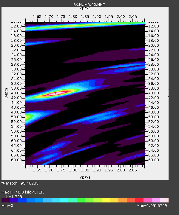
| Estimated Moho Depth: |
40.0 km |
| Estimated Crust Vp/Vs: |
1.73 |
| Assumed Crust Vp: |
6.522 km/s |
| Estimated Crust Vs: |
3.781 km/s |
| Estimated Crust Poisson's Ratio: |
0.25 |
|
| Radial Match: |
95.46233 % |
| Radial Bump: |
254 |
| Transverse Match: |
94.20333 % |
| Transverse Bump: |
318 |
| SOD ConfigId: |
803114 |
| Insert Time: |
2014-10-23 02:21:11.525 +0000 |
| GWidth: |
2.5 |
| Max Bumps: |
400 |
| Tol: |
0.001 |
|

Signal To Noise
| Channel | StoN | STA | LTA |
| BK:HUMO:00:HHZ:20141009T02:25:43.167991Z | 13.775218 | 2.1501476E-6 | 1.560881E-7 |
| BK:HUMO:00:HHN:20141009T02:25:43.167991Z | 5.7173963 | 8.130679E-7 | 1.4220947E-7 |
| BK:HUMO:00:HHE:20141009T02:25:43.167991Z | 1.9097317 | 3.435108E-7 | 1.7987385E-7 |
| Arrivals |
| Ps | 4.6 SECOND |
| PpPs | 16 SECOND |
| PsPs/PpSs | 21 SECOND |


