You are here: Home > Network List > YB13 - Continental Dynamics/Cent. Anatolian Tectonics:Surface to Mantle Dynamics During Stations List
> Station AT21 Asiklar,Nevsehir,Turkey > Earthquake Result Viewer
AT21 Asiklar,Nevsehir,Turkey - Earthquake Result Viewer
| Earthquake location: |
Southeast Of Honshu, Japan |
| Earthquake latitude/longitude: |
31.6/140.2 |
| Earthquake time(UTC): |
2015/05/02 (122) 16:50:46 GMT |
| Earthquake Depth: |
32 km |
| Earthquake Magnitude: |
5.7 MB |
| Earthquake Catalog/Contributor: |
NEIC PDE/NEIC ALERT |
|
| Network: |
YB Continental Dynamics/Cent. Anatolian Tectonics:Surface to Mantle Dynamics During |
| Station: |
AT21 Asiklar,Nevsehir,Turkey |
| Lat/Lon: |
38.93 N/34.52 E |
| Elevation: |
1279 m |
|
| Distance: |
81.6 deg |
| Az: |
310.594 deg |
| Baz: |
56.175 deg |
| Ray Param: |
0.04745667 |
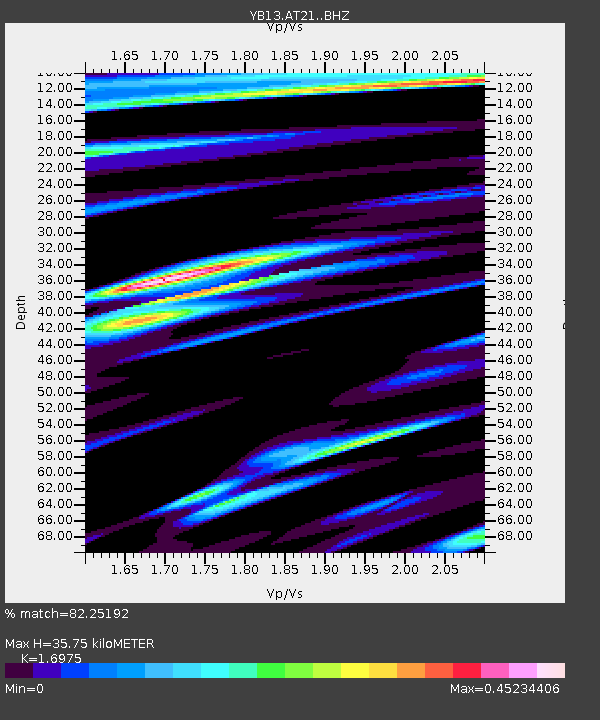
| Estimated Moho Depth: |
35.75 km |
| Estimated Crust Vp/Vs: |
1.70 |
| Assumed Crust Vp: |
6.35 km/s |
| Estimated Crust Vs: |
3.741 km/s |
| Estimated Crust Poisson's Ratio: |
0.23 |
|
| Radial Match: |
82.25192 % |
| Radial Bump: |
400 |
| Transverse Match: |
68.42666 % |
| Transverse Bump: |
400 |
| SOD ConfigId: |
7422571 |
| Insert Time: |
2019-04-18 15:20:49.617 +0000 |
| GWidth: |
2.5 |
| Max Bumps: |
400 |
| Tol: |
0.001 |
|

Signal To Noise
| Channel | StoN | STA | LTA |
| YB:AT21: :BHZ:20150502T17:02:30.519971Z | 3.7935863 | 1.6066095E-7 | 4.2350678E-8 |
| YB:AT21: :BHN:20150502T17:02:30.519971Z | 2.329202 | 6.0654514E-8 | 2.60409E-8 |
| YB:AT21: :BHE:20150502T17:02:30.519971Z | 1.1863936 | 3.3947764E-8 | 2.8614249E-8 |
| Arrivals |
| Ps | 4.0 SECOND |
| PpPs | 15 SECOND |
| PsPs/PpSs | 19 SECOND |


