You are here: Home > Network List > CO - South Carolina Seismic Network Stations List
> Station PAULI Pauline, SC, USA > Earthquake Result Viewer
PAULI Pauline, SC, USA - Earthquake Result Viewer
| Earthquake location: |
Southern East Pacific Rise |
| Earthquake latitude/longitude: |
-32.1/-110.8 |
| Earthquake time(UTC): |
2014/10/09 (282) 02:14:32 GMT |
| Earthquake Depth: |
16 km |
| Earthquake Magnitude: |
7.1 MWW, 6.8 MI |
| Earthquake Catalog/Contributor: |
NEIC PDE/NEIC COMCAT |
|
| Network: |
CO South Carolina Seismic Network |
| Station: |
PAULI Pauline, SC, USA |
| Lat/Lon: |
34.82 N/81.81 W |
| Elevation: |
179 m |
|
| Distance: |
71.9 deg |
| Az: |
24.777 deg |
| Baz: |
205.611 deg |
| Ray Param: |
0.053985383 |
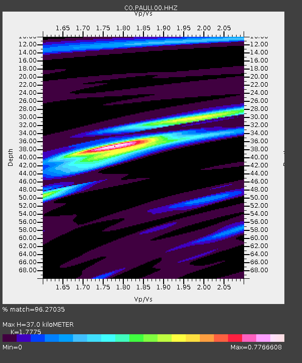
| Estimated Moho Depth: |
37.0 km |
| Estimated Crust Vp/Vs: |
1.78 |
| Assumed Crust Vp: |
6.419 km/s |
| Estimated Crust Vs: |
3.611 km/s |
| Estimated Crust Poisson's Ratio: |
0.27 |
|
| Radial Match: |
96.27035 % |
| Radial Bump: |
227 |
| Transverse Match: |
87.29481 % |
| Transverse Bump: |
400 |
| SOD ConfigId: |
803114 |
| Insert Time: |
2014-10-23 02:26:29.402 +0000 |
| GWidth: |
2.5 |
| Max Bumps: |
400 |
| Tol: |
0.001 |
|

Signal To Noise
| Channel | StoN | STA | LTA |
| CO:PAULI:00:HHZ:20141009T02:25:24.05001Z | 16.679937 | 1.9434494E-6 | 1.1651419E-7 |
| CO:PAULI:00:HHN:20141009T02:25:24.05001Z | 11.994115 | 7.4777694E-7 | 6.2345315E-8 |
| CO:PAULI:00:HHE:20141009T02:25:24.05001Z | 3.5615704 | 3.121135E-7 | 8.763367E-8 |
| Arrivals |
| Ps | 4.6 SECOND |
| PpPs | 15 SECOND |
| PsPs/PpSs | 20 SECOND |


