You are here: Home > Network List > G - GEOSCOPE Stations List
> Station FDF Fort de France, Martinique France > Earthquake Result Viewer
FDF Fort de France, Martinique France - Earthquake Result Viewer

| Earthquake location: |
Southern East Pacific Rise |
| Earthquake latitude/longitude: |
-32.1/-110.8 |
| Earthquake time(UTC): |
2014/10/09 (282) 02:14:32 GMT |
| Earthquake Depth: |
16 km |
| Earthquake Magnitude: |
7.1 MWW, 6.8 MI |
| Earthquake Catalog/Contributor: |
NEIC PDE/NEIC COMCAT |
|
| Network: |
G GEOSCOPE |
| Station: |
FDF Fort de France, Martinique France |
| Lat/Lon: |
14.73 N/61.14 W |
| Elevation: |
467 m |
|
| Distance: |
66.5 deg |
| Az: |
53.475 deg |
| Baz: |
224.814 deg |
| Ray Param: |
0.057533454 |
| Estimated Moho Depth: |
25.5 km |
| Estimated Crust Vp/Vs: |
1.72 |
| Assumed Crust Vp: |
5.88 km/s |
| Estimated Crust Vs: |
3.414 km/s |
| Estimated Crust Poisson's Ratio: |
0.25 |
|
| Radial Match: |
93.48821 % |
| Radial Bump: |
400 |
| Transverse Match: |
90.67449 % |
| Transverse Bump: |
400 |
| SOD ConfigId: |
803114 |
| Insert Time: |
2014-10-23 02:27:22.136 +0000 |
| GWidth: |
2.5 |
| Max Bumps: |
400 |
| Tol: |
0.001 |
|
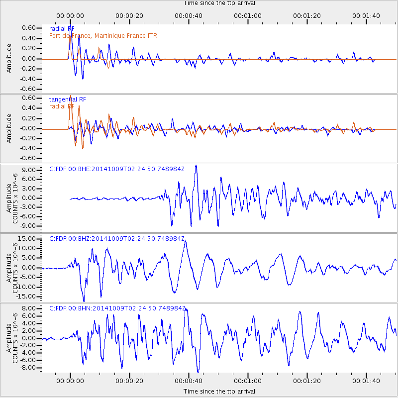
Signal To Noise
| Channel | StoN | STA | LTA |
| G:FDF:00:BHZ:20141009T02:24:50.748984Z | 51.647987 | 6.998088E-6 | 1.3549585E-7 |
| G:FDF:00:BHN:20141009T02:24:50.748984Z | 10.843574 | 2.404185E-6 | 2.2171518E-7 |
| G:FDF:00:BHE:20141009T02:24:50.748984Z | 14.334474 | 3.0895653E-6 | 2.1553393E-7 |
| Arrivals |
| Ps | 3.2 SECOND |
| PpPs | 11 SECOND |
| PsPs/PpSs | 15 SECOND |


