You are here: Home > Network List > IW - Intermountain West Stations List
> Station PLID Pearl Lake, Idaho, USA > Earthquake Result Viewer
PLID Pearl Lake, Idaho, USA - Earthquake Result Viewer
| Earthquake location: |
Southern East Pacific Rise |
| Earthquake latitude/longitude: |
-32.1/-110.8 |
| Earthquake time(UTC): |
2014/10/09 (282) 02:14:32 GMT |
| Earthquake Depth: |
16 km |
| Earthquake Magnitude: |
7.1 MWW, 6.8 MI |
| Earthquake Catalog/Contributor: |
NEIC PDE/NEIC COMCAT |
|
| Network: |
IW Intermountain West |
| Station: |
PLID Pearl Lake, Idaho, USA |
| Lat/Lon: |
45.09 N/116.00 W |
| Elevation: |
2164 m |
|
| Distance: |
77.0 deg |
| Az: |
356.206 deg |
| Baz: |
175.454 deg |
| Ray Param: |
0.05061761 |
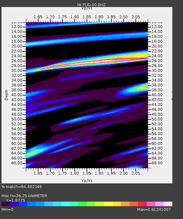
| Estimated Moho Depth: |
26.25 km |
| Estimated Crust Vp/Vs: |
1.88 |
| Assumed Crust Vp: |
6.571 km/s |
| Estimated Crust Vs: |
3.5 km/s |
| Estimated Crust Poisson's Ratio: |
0.30 |
|
| Radial Match: |
94.482346 % |
| Radial Bump: |
300 |
| Transverse Match: |
89.202095 % |
| Transverse Bump: |
400 |
| SOD ConfigId: |
803114 |
| Insert Time: |
2014-10-23 02:30:58.667 +0000 |
| GWidth: |
2.5 |
| Max Bumps: |
400 |
| Tol: |
0.001 |
|
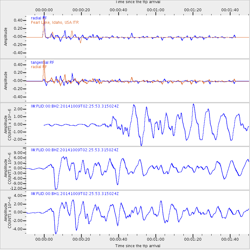
Signal To Noise
| Channel | StoN | STA | LTA |
| IW:PLID:00:BHZ:20141009T02:25:53.315024Z | 8.986288 | 1.4368862E-6 | 1.5989764E-7 |
| IW:PLID:00:BH1:20141009T02:25:53.315024Z | 6.6537466 | 5.5572474E-7 | 8.3520575E-8 |
| IW:PLID:00:BH2:20141009T02:25:53.315024Z | 1.622987 | 1.377802E-7 | 8.489298E-8 |
| Arrivals |
| Ps | 3.6 SECOND |
| PpPs | 11 SECOND |
| PsPs/PpSs | 15 SECOND |


