You are here: Home > Network List > N4 - Central and EAstern US Network Stations List
> Station 146B Union, MS, USA > Earthquake Result Viewer
146B Union, MS, USA - Earthquake Result Viewer
| Earthquake location: |
Southern East Pacific Rise |
| Earthquake latitude/longitude: |
-32.1/-110.8 |
| Earthquake time(UTC): |
2014/10/09 (282) 02:14:32 GMT |
| Earthquake Depth: |
16 km |
| Earthquake Magnitude: |
7.1 MWW, 6.8 MI |
| Earthquake Catalog/Contributor: |
NEIC PDE/NEIC COMCAT |
|
| Network: |
N4 Central and EAstern US Network |
| Station: |
146B Union, MS, USA |
| Lat/Lon: |
32.64 N/89.06 W |
| Elevation: |
161 m |
|
| Distance: |
67.6 deg |
| Az: |
19.741 deg |
| Baz: |
199.859 deg |
| Ray Param: |
0.056844037 |
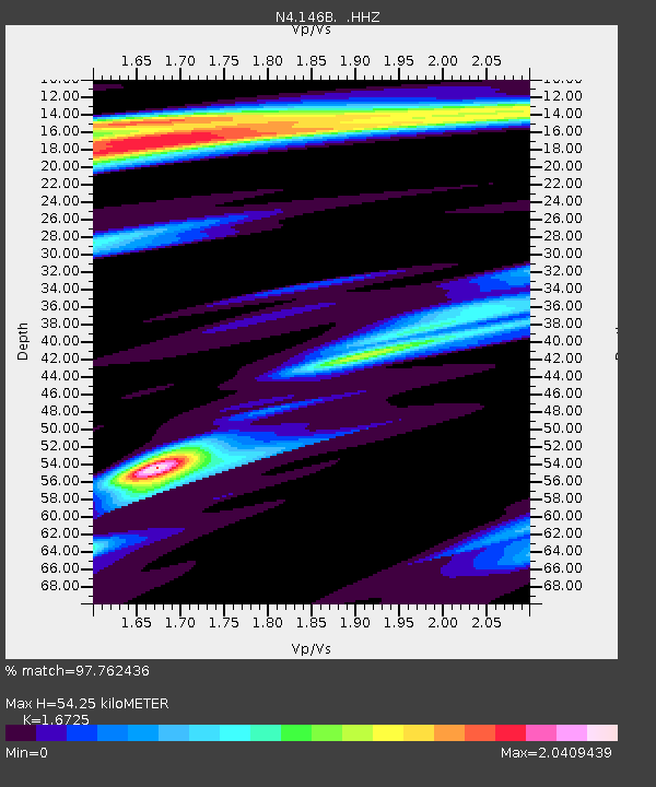
| Estimated Moho Depth: |
54.25 km |
| Estimated Crust Vp/Vs: |
1.67 |
| Assumed Crust Vp: |
6.201 km/s |
| Estimated Crust Vs: |
3.708 km/s |
| Estimated Crust Poisson's Ratio: |
0.22 |
|
| Radial Match: |
97.762436 % |
| Radial Bump: |
199 |
| Transverse Match: |
88.56367 % |
| Transverse Bump: |
326 |
| SOD ConfigId: |
803114 |
| Insert Time: |
2014-10-23 02:33:20.533 +0000 |
| GWidth: |
2.5 |
| Max Bumps: |
400 |
| Tol: |
0.001 |
|

Signal To Noise
| Channel | StoN | STA | LTA |
| N4:146B: :HHZ:20141009T02:24:57.389976Z | 8.719119 | 2.0420239E-6 | 2.3420071E-7 |
| N4:146B: :HHN:20141009T02:24:57.389976Z | 2.648707 | 1.1283921E-6 | 4.260162E-7 |
| N4:146B: :HHE:20141009T02:24:57.389976Z | 0.83233595 | 3.3200084E-7 | 3.988784E-7 |
| Arrivals |
| Ps | 6.1 SECOND |
| PpPs | 22 SECOND |
| PsPs/PpSs | 29 SECOND |


