You are here: Home > Network List > N4 - Central and EAstern US Network Stations List
> Station 152A Waverly Hall, GA, USA > Earthquake Result Viewer
152A Waverly Hall, GA, USA - Earthquake Result Viewer
| Earthquake location: |
Southern East Pacific Rise |
| Earthquake latitude/longitude: |
-32.1/-110.8 |
| Earthquake time(UTC): |
2014/10/09 (282) 02:14:32 GMT |
| Earthquake Depth: |
16 km |
| Earthquake Magnitude: |
7.1 MWW, 6.8 MI |
| Earthquake Catalog/Contributor: |
NEIC PDE/NEIC COMCAT |
|
| Network: |
N4 Central and EAstern US Network |
| Station: |
152A Waverly Hall, GA, USA |
| Lat/Lon: |
32.67 N/84.72 W |
| Elevation: |
214 m |
|
| Distance: |
69.0 deg |
| Az: |
23.388 deg |
| Baz: |
203.54 deg |
| Ray Param: |
0.055940613 |
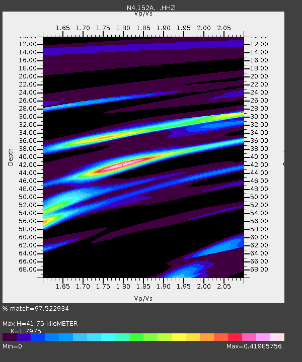
| Estimated Moho Depth: |
41.75 km |
| Estimated Crust Vp/Vs: |
1.80 |
| Assumed Crust Vp: |
6.719 km/s |
| Estimated Crust Vs: |
3.738 km/s |
| Estimated Crust Poisson's Ratio: |
0.28 |
|
| Radial Match: |
97.522934 % |
| Radial Bump: |
148 |
| Transverse Match: |
89.37819 % |
| Transverse Bump: |
400 |
| SOD ConfigId: |
803114 |
| Insert Time: |
2014-10-23 02:33:21.542 +0000 |
| GWidth: |
2.5 |
| Max Bumps: |
400 |
| Tol: |
0.001 |
|

Signal To Noise
| Channel | StoN | STA | LTA |
| N4:152A: :HHZ:20141009T02:25:06.01998Z | 18.876207 | 1.9219524E-6 | 1.01818785E-7 |
| N4:152A: :HHN:20141009T02:25:06.01998Z | 8.430493 | 8.0823304E-7 | 9.58702E-8 |
| N4:152A: :HHE:20141009T02:25:06.01998Z | 3.8401153 | 3.5914272E-7 | 9.352394E-8 |
| Arrivals |
| Ps | 5.2 SECOND |
| PpPs | 17 SECOND |
| PsPs/PpSs | 22 SECOND |


