You are here: Home > Network List > N4 - Central and EAstern US Network Stations List
> Station P38B Dawn, MO, USA > Earthquake Result Viewer
P38B Dawn, MO, USA - Earthquake Result Viewer
| Earthquake location: |
Southern East Pacific Rise |
| Earthquake latitude/longitude: |
-32.1/-110.8 |
| Earthquake time(UTC): |
2014/10/09 (282) 02:14:32 GMT |
| Earthquake Depth: |
16 km |
| Earthquake Magnitude: |
7.1 MWW, 6.8 MI |
| Earthquake Catalog/Contributor: |
NEIC PDE/NEIC COMCAT |
|
| Network: |
N4 Central and EAstern US Network |
| Station: |
P38B Dawn, MO, USA |
| Lat/Lon: |
39.62 N/93.53 W |
| Elevation: |
248 m |
|
| Distance: |
73.2 deg |
| Az: |
13.843 deg |
| Baz: |
195.241 deg |
| Ray Param: |
0.053182606 |
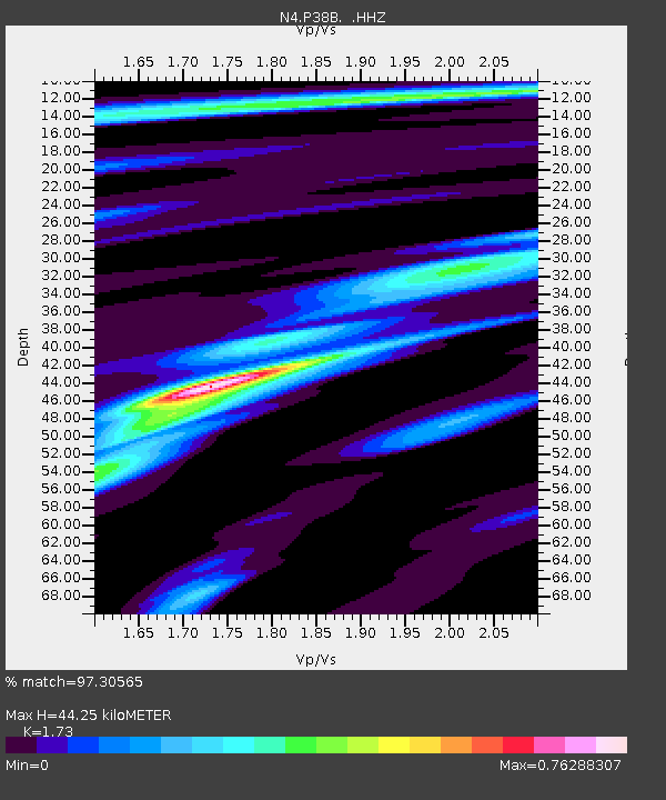
| Estimated Moho Depth: |
44.25 km |
| Estimated Crust Vp/Vs: |
1.73 |
| Assumed Crust Vp: |
6.498 km/s |
| Estimated Crust Vs: |
3.756 km/s |
| Estimated Crust Poisson's Ratio: |
0.25 |
|
| Radial Match: |
97.30565 % |
| Radial Bump: |
217 |
| Transverse Match: |
91.05549 % |
| Transverse Bump: |
335 |
| SOD ConfigId: |
803114 |
| Insert Time: |
2014-10-23 02:35:11.536 +0000 |
| GWidth: |
2.5 |
| Max Bumps: |
400 |
| Tol: |
0.001 |
|

Signal To Noise
| Channel | StoN | STA | LTA |
| N4:P38B: :HHZ:20141009T02:25:31.26998Z | 18.516708 | 2.2647005E-6 | 1.2230578E-7 |
| N4:P38B: :HHN:20141009T02:25:31.26998Z | 7.787973 | 9.641406E-7 | 1.2379866E-7 |
| N4:P38B: :HHE:20141009T02:25:31.26998Z | 2.696994 | 2.8551048E-7 | 1.05862476E-7 |
| Arrivals |
| Ps | 5.2 SECOND |
| PpPs | 18 SECOND |
| PsPs/PpSs | 23 SECOND |


