You are here: Home > Network List > N4 - Central and EAstern US Network Stations List
> Station B35B Bob, Littlefork, MN, USA > Earthquake Result Viewer
B35B Bob, Littlefork, MN, USA - Earthquake Result Viewer
| Earthquake location: |
Southern East Pacific Rise |
| Earthquake latitude/longitude: |
-32.1/-110.8 |
| Earthquake time(UTC): |
2014/10/09 (282) 02:14:32 GMT |
| Earthquake Depth: |
16 km |
| Earthquake Magnitude: |
7.1 MWW, 6.8 MI |
| Earthquake Catalog/Contributor: |
NEIC PDE/NEIC COMCAT |
|
| Network: |
N4 Central and EAstern US Network |
| Station: |
B35B Bob, Littlefork, MN, USA |
| Lat/Lon: |
48.36 N/93.73 W |
| Elevation: |
354 m |
|
| Distance: |
81.6 deg |
| Az: |
11.404 deg |
| Baz: |
194.571 deg |
| Ray Param: |
0.047494397 |
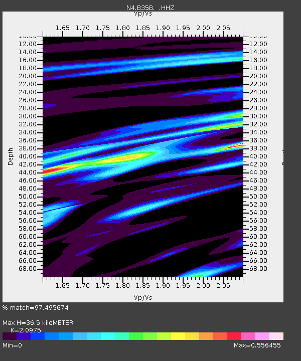
| Estimated Moho Depth: |
36.5 km |
| Estimated Crust Vp/Vs: |
2.10 |
| Assumed Crust Vp: |
6.419 km/s |
| Estimated Crust Vs: |
3.06 km/s |
| Estimated Crust Poisson's Ratio: |
0.35 |
|
| Radial Match: |
97.495674 % |
| Radial Bump: |
371 |
| Transverse Match: |
89.95116 % |
| Transverse Bump: |
400 |
| SOD ConfigId: |
803114 |
| Insert Time: |
2014-10-23 02:36:50.504 +0000 |
| GWidth: |
2.5 |
| Max Bumps: |
400 |
| Tol: |
0.001 |
|

Signal To Noise
| Channel | StoN | STA | LTA |
| N4:B35B: :HHZ:20141009T02:26:18.190024Z | 10.317161 | 2.2867523E-6 | 2.2164551E-7 |
| N4:B35B: :HHN:20141009T02:26:18.190024Z | 4.8837175 | 8.3193345E-7 | 1.703484E-7 |
| N4:B35B: :HHE:20141009T02:26:18.190024Z | 2.0499737 | 2.6168073E-7 | 1.2765076E-7 |
| Arrivals |
| Ps | 6.4 SECOND |
| PpPs | 17 SECOND |
| PsPs/PpSs | 24 SECOND |


