You are here: Home > Network List > N4 - Central and EAstern US Network Stations List
> Station L48A N Adams, MI, USA > Earthquake Result Viewer
L48A N Adams, MI, USA - Earthquake Result Viewer
| Earthquake location: |
Southern East Pacific Rise |
| Earthquake latitude/longitude: |
-32.1/-110.8 |
| Earthquake time(UTC): |
2014/10/09 (282) 02:14:32 GMT |
| Earthquake Depth: |
16 km |
| Earthquake Magnitude: |
7.1 MWW, 6.8 MI |
| Earthquake Catalog/Contributor: |
NEIC PDE/NEIC COMCAT |
|
| Network: |
N4 Central and EAstern US Network |
| Station: |
L48A N Adams, MI, USA |
| Lat/Lon: |
41.94 N/84.43 W |
| Elevation: |
369 m |
|
| Distance: |
77.6 deg |
| Az: |
19.816 deg |
| Baz: |
202.682 deg |
| Ray Param: |
0.05021282 |
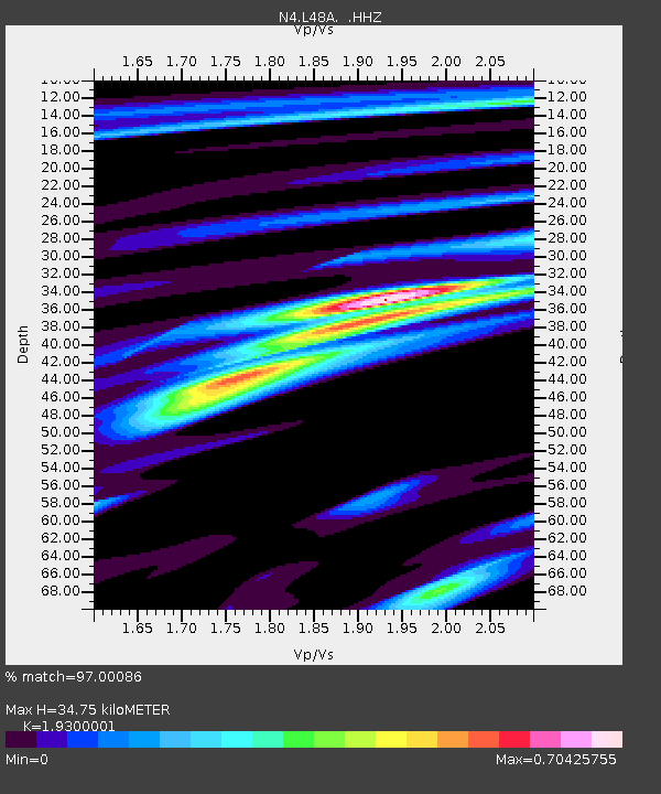
| Estimated Moho Depth: |
34.75 km |
| Estimated Crust Vp/Vs: |
1.93 |
| Assumed Crust Vp: |
6.498 km/s |
| Estimated Crust Vs: |
3.367 km/s |
| Estimated Crust Poisson's Ratio: |
0.32 |
|
| Radial Match: |
97.00086 % |
| Radial Bump: |
219 |
| Transverse Match: |
80.9471 % |
| Transverse Bump: |
400 |
| SOD ConfigId: |
803114 |
| Insert Time: |
2014-10-23 02:37:07.080 +0000 |
| GWidth: |
2.5 |
| Max Bumps: |
400 |
| Tol: |
0.001 |
|

Signal To Noise
| Channel | StoN | STA | LTA |
| N4:L48A: :HHZ:20141009T02:25:56.670005Z | 15.294225 | 2.2830086E-6 | 1.492726E-7 |
| N4:L48A: :HHN:20141009T02:25:56.670005Z | 5.6032047 | 8.0269405E-7 | 1.4325623E-7 |
| N4:L48A: :HHE:20141009T02:25:56.670005Z | 2.1042702 | 5.0103154E-7 | 2.3810226E-7 |
| Arrivals |
| Ps | 5.1 SECOND |
| PpPs | 15 SECOND |
| PsPs/PpSs | 20 SECOND |


