You are here: Home > Network List > IU - Global Seismograph Network (GSN - IRIS/USGS) Stations List
> Station GRFO Grafenberg, Germany > Earthquake Result Viewer
GRFO Grafenberg, Germany - Earthquake Result Viewer
| Earthquake location: |
Central Mexico |
| Earthquake latitude/longitude: |
18.4/-97.4 |
| Earthquake time(UTC): |
1999/06/15 (166) 20:42:05 GMT |
| Earthquake Depth: |
70 km |
| Earthquake Magnitude: |
6.4 MB, 6.5 MS, 7.0 MW, 6.7 ME |
| Earthquake Catalog/Contributor: |
WHDF/NEIC |
|
| Network: |
IU Global Seismograph Network (GSN - IRIS/USGS) |
| Station: |
GRFO Grafenberg, Germany |
| Lat/Lon: |
49.69 N/11.22 E |
| Elevation: |
425 m |
|
| Distance: |
87.6 deg |
| Az: |
38.011 deg |
| Baz: |
295.784 deg |
| Ray Param: |
0.043042656 |
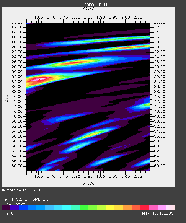
| Estimated Moho Depth: |
32.75 km |
| Estimated Crust Vp/Vs: |
1.65 |
| Assumed Crust Vp: |
6.182 km/s |
| Estimated Crust Vs: |
3.741 km/s |
| Estimated Crust Poisson's Ratio: |
0.21 |
|
| Radial Match: |
97.17638 % |
| Radial Bump: |
400 |
| Transverse Match: |
93.98781 % |
| Transverse Bump: |
400 |
| SOD ConfigId: |
4480 |
| Insert Time: |
2010-03-02 02:07:12.346 +0000 |
| GWidth: |
2.5 |
| Max Bumps: |
400 |
| Tol: |
0.001 |
|

Signal To Noise
| Channel | StoN | STA | LTA |
| IU:GRFO: :BHN:19990615T20:54:15.471016Z | 19.900808 | 1.3901825E-6 | 6.985558E-8 |
| IU:GRFO: :BHE:19990615T20:54:15.471016Z | 1.2634733 | 7.382719E-8 | 5.8431937E-8 |
| IU:GRFO: :BHZ:19990615T20:54:15.471016Z | 4.9963603 | 4.5410317E-7 | 9.088679E-8 |
| Arrivals |
| Ps | 3.5 SECOND |
| PpPs | 14 SECOND |
| PsPs/PpSs | 17 SECOND |


