You are here: Home > Network List > NM - Cooperative New Madrid Seismic Network Stations List
> Station GNAR Gosnell,AR > Earthquake Result Viewer
GNAR Gosnell,AR - Earthquake Result Viewer
| Earthquake location: |
Southern East Pacific Rise |
| Earthquake latitude/longitude: |
-32.1/-110.8 |
| Earthquake time(UTC): |
2014/10/09 (282) 02:14:32 GMT |
| Earthquake Depth: |
16 km |
| Earthquake Magnitude: |
7.1 MWW, 6.8 MI |
| Earthquake Catalog/Contributor: |
NEIC PDE/NEIC COMCAT |
|
| Network: |
NM Cooperative New Madrid Seismic Network |
| Station: |
GNAR Gosnell,AR |
| Lat/Lon: |
35.97 N/90.02 W |
| Elevation: |
71 m |
|
| Distance: |
70.5 deg |
| Az: |
17.766 deg |
| Baz: |
198.613 deg |
| Ray Param: |
0.054953434 |
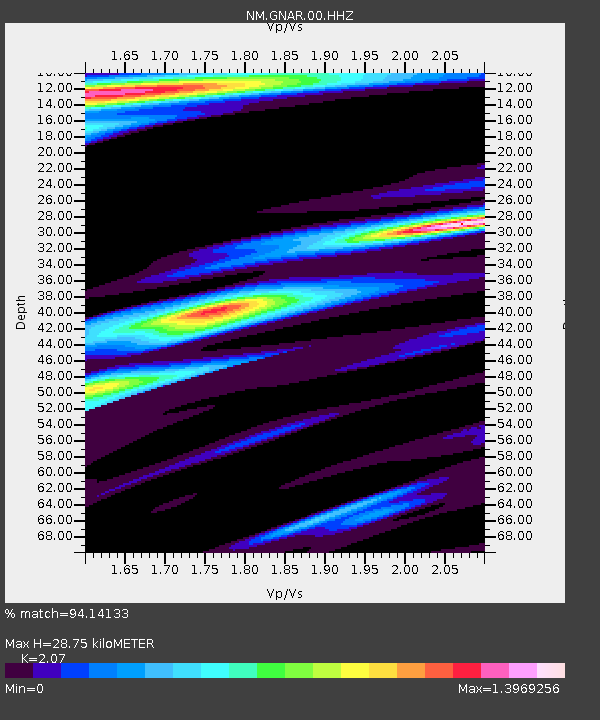
| Estimated Moho Depth: |
28.75 km |
| Estimated Crust Vp/Vs: |
2.07 |
| Assumed Crust Vp: |
6.273 km/s |
| Estimated Crust Vs: |
3.031 km/s |
| Estimated Crust Poisson's Ratio: |
0.35 |
|
| Radial Match: |
94.14133 % |
| Radial Bump: |
350 |
| Transverse Match: |
82.68378 % |
| Transverse Bump: |
370 |
| SOD ConfigId: |
803114 |
| Insert Time: |
2014-10-23 02:38:31.797 +0000 |
| GWidth: |
2.5 |
| Max Bumps: |
400 |
| Tol: |
0.001 |
|

Signal To Noise
| Channel | StoN | STA | LTA |
| NM:GNAR:00:HHZ:20141009T02:25:15.18502Z | 9.17456 | 2.0302298E-6 | 2.2128907E-7 |
| NM:GNAR:00:HHN:20141009T02:25:15.18502Z | 1.687065 | 1.2151927E-6 | 7.202999E-7 |
| NM:GNAR:00:HHE:20141009T02:25:15.18502Z | 1.4896555 | 7.3247344E-7 | 4.917066E-7 |
| Arrivals |
| Ps | 5.1 SECOND |
| PpPs | 14 SECOND |
| PsPs/PpSs | 19 SECOND |


