You are here: Home > Network List > NM - Cooperative New Madrid Seismic Network Stations List
> Station MGMO Mountain Grove, MO > Earthquake Result Viewer
MGMO Mountain Grove, MO - Earthquake Result Viewer
| Earthquake location: |
Southern East Pacific Rise |
| Earthquake latitude/longitude: |
-32.1/-110.8 |
| Earthquake time(UTC): |
2014/10/09 (282) 02:14:32 GMT |
| Earthquake Depth: |
16 km |
| Earthquake Magnitude: |
7.1 MWW, 6.8 MI |
| Earthquake Catalog/Contributor: |
NEIC PDE/NEIC COMCAT |
|
| Network: |
NM Cooperative New Madrid Seismic Network |
| Station: |
MGMO Mountain Grove, MO |
| Lat/Lon: |
37.15 N/92.27 W |
| Elevation: |
453 m |
|
| Distance: |
71.0 deg |
| Az: |
15.556 deg |
| Baz: |
196.549 deg |
| Ray Param: |
0.05456642 |
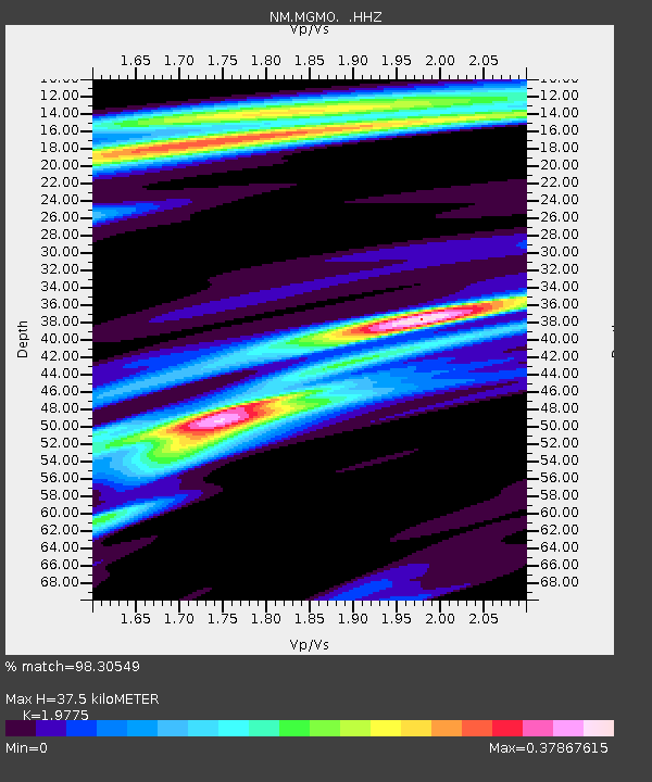
| Estimated Moho Depth: |
37.5 km |
| Estimated Crust Vp/Vs: |
1.98 |
| Assumed Crust Vp: |
6.53 km/s |
| Estimated Crust Vs: |
3.302 km/s |
| Estimated Crust Poisson's Ratio: |
0.33 |
|
| Radial Match: |
98.30549 % |
| Radial Bump: |
198 |
| Transverse Match: |
86.74711 % |
| Transverse Bump: |
392 |
| SOD ConfigId: |
803114 |
| Insert Time: |
2014-10-23 02:38:47.156 +0000 |
| GWidth: |
2.5 |
| Max Bumps: |
400 |
| Tol: |
0.001 |
|

Signal To Noise
| Channel | StoN | STA | LTA |
| NM:MGMO: :HHZ:20141009T02:25:18.717979Z | 12.954927 | 1.500045E-6 | 1.15789526E-7 |
| NM:MGMO: :HHN:20141009T02:25:18.717979Z | 7.402175 | 6.493368E-7 | 8.7722434E-8 |
| NM:MGMO: :HHE:20141009T02:25:18.717979Z | 3.1737995 | 3.5190442E-7 | 1.1087796E-7 |
| Arrivals |
| Ps | 5.8 SECOND |
| PpPs | 17 SECOND |
| PsPs/PpSs | 22 SECOND |


