You are here: Home > Network List > IU - Global Seismograph Network (GSN - IRIS/USGS) Stations List
> Station GRFO Grafenberg, Germany > Earthquake Result Viewer
GRFO Grafenberg, Germany - Earthquake Result Viewer

| Earthquake location: |
Hindu Kush Region, Afghanistan |
| Earthquake latitude/longitude: |
36.4/70.4 |
| Earthquake time(UTC): |
2002/03/03 (062) 12:08:07 GMT |
| Earthquake Depth: |
209 km |
| Earthquake Magnitude: |
6.3 MB |
| Earthquake Catalog/Contributor: |
WHDF/NEIC |
|
| Network: |
IU Global Seismograph Network (GSN - IRIS/USGS) |
| Station: |
GRFO Grafenberg, Germany |
| Lat/Lon: |
49.69 N/11.22 E |
| Elevation: |
425 m |
|
| Distance: |
44.1 deg |
| Az: |
306.76 deg |
| Baz: |
84.224 deg |
| Ray Param: |
0.07129232 |
| Estimated Moho Depth: |
31.25 km |
| Estimated Crust Vp/Vs: |
1.71 |
| Assumed Crust Vp: |
6.182 km/s |
| Estimated Crust Vs: |
3.61 km/s |
| Estimated Crust Poisson's Ratio: |
0.24 |
|
| Radial Match: |
97.23232 % |
| Radial Bump: |
268 |
| Transverse Match: |
82.94453 % |
| Transverse Bump: |
400 |
| SOD ConfigId: |
20082 |
| Insert Time: |
2010-03-02 02:07:39.633 +0000 |
| GWidth: |
2.5 |
| Max Bumps: |
400 |
| Tol: |
0.001 |
|
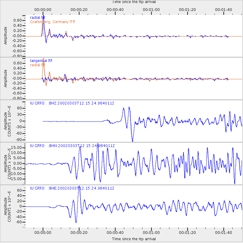
Signal To Noise
| Channel | StoN | STA | LTA |
| IU:GRFO: :BHN:20020303T12:15:24.984011Z | 0.78841794 | 2.844459E-7 | 3.6078058E-7 |
| IU:GRFO: :BHE:20020303T12:15:24.984011Z | 5.3933024 | 1.3007639E-6 | 2.4118134E-7 |
| IU:GRFO: :BHZ:20020303T12:15:24.984011Z | 7.26563 | 2.2227628E-6 | 3.0592844E-7 |
| Arrivals |
| Ps | 3.8 SECOND |
| PpPs | 13 SECOND |
| PsPs/PpSs | 17 SECOND |


