You are here: Home > Network List > TA - USArray Transportable Network (new EarthScope stations) Stations List
> Station A04D Lummi Island, WA, USA > Earthquake Result Viewer
A04D Lummi Island, WA, USA - Earthquake Result Viewer
| Earthquake location: |
Southern East Pacific Rise |
| Earthquake latitude/longitude: |
-32.1/-110.8 |
| Earthquake time(UTC): |
2014/10/09 (282) 02:14:32 GMT |
| Earthquake Depth: |
16 km |
| Earthquake Magnitude: |
7.1 MWW, 6.8 MI |
| Earthquake Catalog/Contributor: |
NEIC PDE/NEIC COMCAT |
|
| Network: |
TA USArray Transportable Network (new EarthScope stations) |
| Station: |
A04D Lummi Island, WA, USA |
| Lat/Lon: |
48.72 N/122.71 W |
| Elevation: |
13 m |
|
| Distance: |
81.2 deg |
| Az: |
352.039 deg |
| Baz: |
169.777 deg |
| Ray Param: |
0.04776128 |
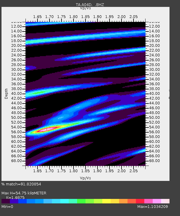
| Estimated Moho Depth: |
54.75 km |
| Estimated Crust Vp/Vs: |
1.69 |
| Assumed Crust Vp: |
6.566 km/s |
| Estimated Crust Vs: |
3.891 km/s |
| Estimated Crust Poisson's Ratio: |
0.23 |
|
| Radial Match: |
91.820854 % |
| Radial Bump: |
400 |
| Transverse Match: |
89.271095 % |
| Transverse Bump: |
400 |
| SOD ConfigId: |
803114 |
| Insert Time: |
2014-10-23 02:45:35.095 +0000 |
| GWidth: |
2.5 |
| Max Bumps: |
400 |
| Tol: |
0.001 |
|
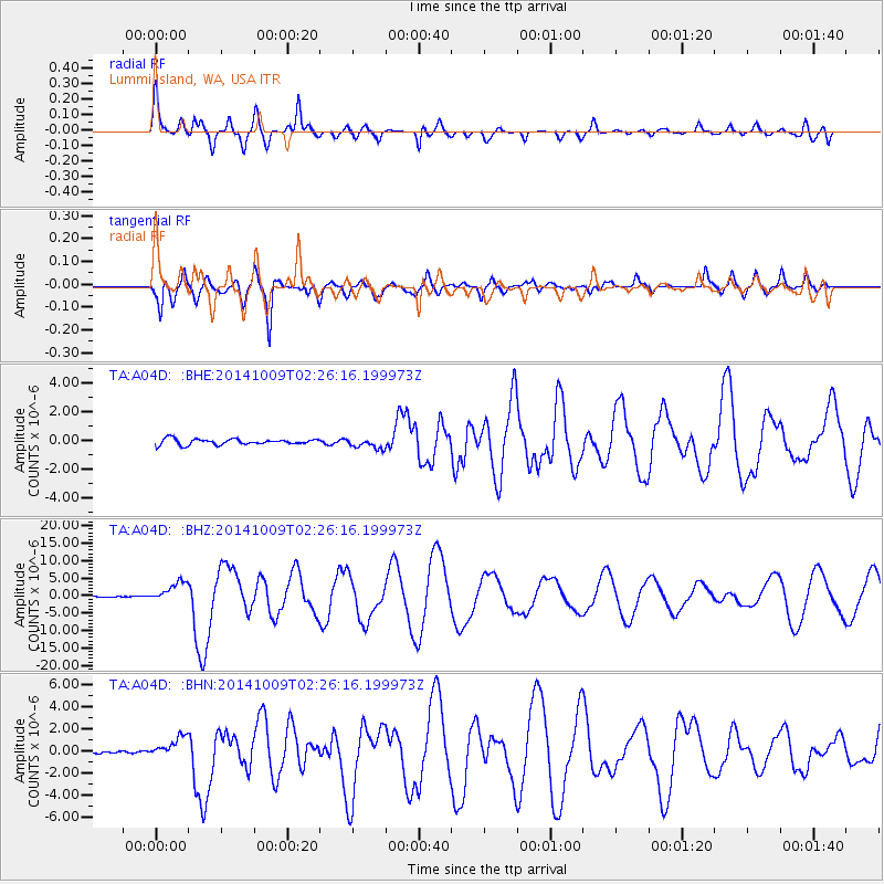
Signal To Noise
| Channel | StoN | STA | LTA |
| TA:A04D: :BHZ:20141009T02:26:16.199973Z | 16.742714 | 2.875038E-6 | 1.7171877E-7 |
| TA:A04D: :BHN:20141009T02:26:16.199973Z | 4.0757155 | 9.590433E-7 | 2.3530674E-7 |
| TA:A04D: :BHE:20141009T02:26:16.199973Z | 1.7851205 | 3.5389687E-7 | 1.9824817E-7 |
| Arrivals |
| Ps | 5.9 SECOND |
| PpPs | 22 SECOND |
| PsPs/PpSs | 28 SECOND |


