You are here: Home > Network List > TA - USArray Transportable Network (new EarthScope stations) Stations List
> Station F04D Rainier, OR, USA > Earthquake Result Viewer
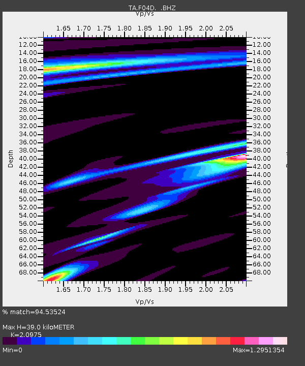
F04D Rainier, OR, USA - Earthquake Result Viewer
| Earthquake location: |
Southern East Pacific Rise |
| Earthquake latitude/longitude: |
-32.1/-110.8 |
| Earthquake time(UTC): |
2014/10/09 (282) 02:14:32 GMT |
| Earthquake Depth: |
16 km |
| Earthquake Magnitude: |
7.1 MWW, 6.8 MI |
| Earthquake Catalog/Contributor: |
NEIC PDE/NEIC COMCAT |
|
| Network: |
TA USArray Transportable Network (new EarthScope stations) |
| Station: |
F04D Rainier, OR, USA |
| Lat/Lon: |
46.08 N/123.01 W |
| Elevation: |
236 m |
|
| Distance: |
78.6 deg |
| Az: |
351.348 deg |
| Baz: |
169.432 deg |
| Ray Param: |
0.049509495 |
| Estimated Moho Depth: |
39.0 km |
| Estimated Crust Vp/Vs: |
2.10 |
| Assumed Crust Vp: |
6.566 km/s |
| Estimated Crust Vs: |
3.13 km/s |
| Estimated Crust Poisson's Ratio: |
0.35 |
|
| Radial Match: |
94.53524 % |
| Radial Bump: |
316 |
| Transverse Match: |
93.66563 % |
| Transverse Bump: |
348 |
| SOD ConfigId: |
803114 |
| Insert Time: |
2014-10-23 02:46:36.367 +0000 |
| GWidth: |
2.5 |
| Max Bumps: |
400 |
| Tol: |
0.001 |
|

Signal To Noise
| Channel | StoN | STA | LTA |
| TA:F04D: :BHZ:20141009T02:26:02.375022Z | 11.9850235 | 2.7517935E-6 | 2.2960269E-7 |
| TA:F04D: :BHN:20141009T02:26:02.375022Z | 2.461311 | 1.2512473E-6 | 5.083662E-7 |
| TA:F04D: :BHE:20141009T02:26:02.375022Z | 0.9780125 | 5.767783E-7 | 5.897453E-7 |
| Arrivals |
| Ps | 6.7 SECOND |
| PpPs | 18 SECOND |
| PsPs/PpSs | 25 SECOND |


