You are here: Home > Network List > TA - USArray Transportable Network (new EarthScope stations) Stations List
> Station F62A Pittston Farm, Pittston Academy Grant, ME, USA > Earthquake Result Viewer
F62A Pittston Farm, Pittston Academy Grant, ME, USA - Earthquake Result Viewer

| Earthquake location: |
Southern East Pacific Rise |
| Earthquake latitude/longitude: |
-32.1/-110.8 |
| Earthquake time(UTC): |
2014/10/09 (282) 02:14:32 GMT |
| Earthquake Depth: |
16 km |
| Earthquake Magnitude: |
7.1 MWW, 6.8 MI |
| Earthquake Catalog/Contributor: |
NEIC PDE/NEIC COMCAT |
|
| Network: |
TA USArray Transportable Network (new EarthScope stations) |
| Station: |
F62A Pittston Farm, Pittston Academy Grant, ME, USA |
| Lat/Lon: |
45.90 N/69.97 W |
| Elevation: |
331 m |
|
| Distance: |
86.0 deg |
| Az: |
27.229 deg |
| Baz: |
213.778 deg |
| Ray Param: |
0.044357352 |
| Estimated Moho Depth: |
38.0 km |
| Estimated Crust Vp/Vs: |
1.86 |
| Assumed Crust Vp: |
6.419 km/s |
| Estimated Crust Vs: |
3.456 km/s |
| Estimated Crust Poisson's Ratio: |
0.30 |
|
| Radial Match: |
96.13659 % |
| Radial Bump: |
267 |
| Transverse Match: |
91.10047 % |
| Transverse Bump: |
400 |
| SOD ConfigId: |
803114 |
| Insert Time: |
2014-10-23 02:46:55.575 +0000 |
| GWidth: |
2.5 |
| Max Bumps: |
400 |
| Tol: |
0.001 |
|
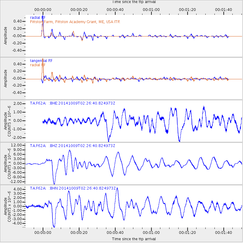
Signal To Noise
| Channel | StoN | STA | LTA |
| TA:F62A: :BHZ:20141009T02:26:40.824973Z | 4.8860865 | 1.8668643E-6 | 3.8207762E-7 |
| TA:F62A: :BHN:20141009T02:26:40.824973Z | 1.9205141 | 5.8307313E-7 | 3.0360263E-7 |
| TA:F62A: :BHE:20141009T02:26:40.824973Z | 2.3010411 | 5.2284855E-7 | 2.2722263E-7 |
| Arrivals |
| Ps | 5.2 SECOND |
| PpPs | 17 SECOND |
| PsPs/PpSs | 22 SECOND |


