You are here: Home > Network List > TA - USArray Transportable Network (new EarthScope stations) Stations List
> Station F64A Sherman, ME, USA > Earthquake Result Viewer
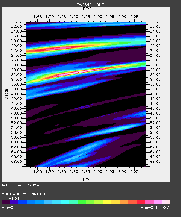
F64A Sherman, ME, USA - Earthquake Result Viewer
| Earthquake location: |
Southern East Pacific Rise |
| Earthquake latitude/longitude: |
-32.1/-110.8 |
| Earthquake time(UTC): |
2014/10/09 (282) 02:14:32 GMT |
| Earthquake Depth: |
16 km |
| Earthquake Magnitude: |
7.1 MWW, 6.8 MI |
| Earthquake Catalog/Contributor: |
NEIC PDE/NEIC COMCAT |
|
| Network: |
TA USArray Transportable Network (new EarthScope stations) |
| Station: |
F64A Sherman, ME, USA |
| Lat/Lon: |
45.86 N/68.35 W |
| Elevation: |
179 m |
|
| Distance: |
86.6 deg |
| Az: |
28.182 deg |
| Baz: |
214.997 deg |
| Ray Param: |
0.043921452 |
| Estimated Moho Depth: |
30.75 km |
| Estimated Crust Vp/Vs: |
1.82 |
| Assumed Crust Vp: |
6.419 km/s |
| Estimated Crust Vs: |
3.532 km/s |
| Estimated Crust Poisson's Ratio: |
0.28 |
|
| Radial Match: |
91.64054 % |
| Radial Bump: |
400 |
| Transverse Match: |
84.339905 % |
| Transverse Bump: |
400 |
| SOD ConfigId: |
803114 |
| Insert Time: |
2014-10-23 02:46:59.978 +0000 |
| GWidth: |
2.5 |
| Max Bumps: |
400 |
| Tol: |
0.001 |
|

Signal To Noise
| Channel | StoN | STA | LTA |
| TA:F64A: :BHZ:20141009T02:26:43.80001Z | 4.173742 | 1.6840257E-6 | 4.0348107E-7 |
| TA:F64A: :BHN:20141009T02:26:43.80001Z | 1.5789472 | 5.486936E-7 | 3.47506E-7 |
| TA:F64A: :BHE:20141009T02:26:43.80001Z | 2.0006874 | 4.7707533E-7 | 2.3845573E-7 |
| Arrivals |
| Ps | 4.0 SECOND |
| PpPs | 13 SECOND |
| PsPs/PpSs | 17 SECOND |


